
When the water rises: Flood risk at two housing estates
Date posted:
Summary
As we now have the threat of a flood hanging over us forever, we would love to sell and move out. But who would buy our property and at what price?
Resident
What we investigated
The Legislative Council required the Ombudsman to investigate flood planning decisions for two housing developments in inner-Melbourne, beside the Maribyrnong River:
- Rivervue Retirement Village (‘Rivervue’)
- Kensington Banks.
Rivervue unexpectedly flooded, badly damaging 45 homes, when the Maribyrnong River burst its banks in October 2022. Homes at Kensington Banks did not flood, but modelling done since shows about 850 are at risk of future flooding.
The Legislative Council required us to look at past and current flood models for the Maribyrnong catchment, and planning decisions for both developments. We were also asked to consider potential policy changes, and whether affected residents should receive compensation or other support.
Why it matters
Though built at different times and with different levels of government involvement, Rivervue and Kensington Banks have much in common. Both involved flood protection works promising to protect homes; and yet both are now considered flood prone.
Together, they tell a broader story about how flood risk is assessed and managed in Victoria, and highlight serious gaps in existing systems.
These have implications for people across the state. Victoria’s Climate Science Report 2024 predicts that, based on current trends, flood risk will double by 2100. Climate change, urban creep, and housing pressures, among other things, mean the way we all live with flood risk must evolve.
What we found
In relation to Rivervue:
- Two early design problems explain the flooding at Rivervue. Melbourne Water’s rushed and flawed flood modelling used during early site development underpredicted flooding. This meant homes were set too low from the start. Mistakes in approved building plans saw some homes built lower still, without a full safety buffer.
- The removal of a key flood planning control had no impact on home design. The two problems existed well before a flood overlay was lifted from Rivervue in late 2016. Looking back now, the removal decision was clearly incorrect. It was understandable though, as Melbourne Water gave advice – based on its flawed modelling – that protective works had effectively lifted homes from the floodplain. We found no evidence of improper influence.
- Vulnerable retirees are left living in a known flood hazard area. Melbourne Water is exploring flood mitigation options for the Maribyrnong catchment, but these could take years to enact. We have recommended a support program to assist affected Rivervue residents who wish to leave in the meantime, and to cover direct financial losses they have already suffered.
In relation to Kensington Banks:
- No red flags stood out in the estate’s original design. Flood protection works at the site in the 1990s were based on good quality modelling and should have been enough to withstand flooding at levels predicted back then. But estimated flood levels are now higher than when the development was planned.
- Multiple factors contributed to the estate’s new flood risk status. The impacts of climate change and urban creep across the catchment are important drivers. Long gaps between flood model updates likely cost early chances to spot looming trouble. And a flood protection levee around the estate appears to have sunk in some places.
- Residents can have confidence in the latest Maribyrnong catchment model. Melbourne Water’s hasty release of results from its 2024 flood model fuelled community concern, but the model is modern, well designed and extensively tested. We have recommended some levee height checks to reinforce trust in the model’s results.
What needs to change
The experiences at Rivervue and Kensington Banks point to a need for broader reforms. We identified three key focus areas:
- Keeping the public informed with accurate and easy to find information. Flood models should be reviewed and updated regularly, with resulting flood maps promptly added to planning schemes. Creating a one-stop, statewide flood information portal will give people easy access to the latest modelling so they can make informed decisions about their safety and property.
- Planning for the impacts of climate shifts. Climate change threatens to upend traditional planning approaches. Catchments are changing, and homes built today must be designed to withstand tomorrow’s conditions. Planning decisions should consider longer-term flood projections, where available.
- Helping people living with flood risk. Major floods are projected to get larger in Victoria, and in coming years many other households will suddenly learn they are at increased risk of flooding. The situations at Rivervue and Kensington Banks are an opportunity to pilot new approaches to supporting people facing an uncertain future.
How Melbourne Water responded
Melbourne Water said it was committed to supporting our investigation, and engaged constructively throughout.
Before our work started, and amid other inquiries, it began overhauling its approach to flood modelling, including clear timeframes for reviewing and updating models, and incorporating climate change projections.
Melbourne Water told us it had learnt from community feedback around the release of the 2024 Maribyrnong catchment flood model, and would allow this to shape the rollout of its broader flood modelling program.
It also said it would work closely with the Victorian Government to address our recommendations.
Background
How we investigated
The Legislative Council referred a matter to us for investigation. Under our legislation, if either House of Parliament or a Parliamentary Committee refers a matter to us, we are required to investigate and report to Parliament without delay.
The referral required us to examine flood planning decisions for two housing developments in inner-Melbourne, both beside the Maribyrnong River:
- Rivervue Retirement Village (‘Rivervue’)
- Kensington Banks.
Many homes at Rivervue unexpectedly flooded in October 2022, when the Maribyrnong River burst its banks. Homes at Kensington Banks did not flood, but modelling done since shows both developments are at risk of future flooding.
The Legislative Council referral (see Figure 1) required us to look at past and current flood models for the Maribyrnong catchment, and planning decisions for both developments. It also required us to consider potential policy changes, and whether affected residents should receive compensation or other support.
Figure 1 Extract of Legislative Council referral letter
Source: Legislative Council
Submissions
The Legislative Council included a requirement for us to hold a day of public hearings as part of our investigation. However, we do not have the power to hold public hearings under the Ombudsman Act.
Instead, we invited submissions from Rivervue and Kensington Banks residents and other interested parties with information about flooding.
People making submissions were encouraged to share their experiences of the October 2022 flood and the 2024 release of new Melbourne Water flood maps, as well as any thoughts on improving how flood risk is managed.
We took submissions confidentially by phone, email, online form and in person. We received 59 in total, most online. This included 22 submissions from residents at Rivervue (all suffered flooding), 28 from residents at Kensington Banks, and a detailed submission from the Rivervue Residents’ Committee.
Residents quoted in the report are not identified by name to protect their privacy.
We also received submissions from:
- Melbourne Water
- Moonee Valley City Council
- the Municipal Association of Victoria
- the Maribyrnong Community Recovery Association
- the Kensington Association
- the Insurance Council of Australia.
Submissions helped us understand how people are impacted by flooding and flood-related planning decisions, and how these decisions are made.
We also spoke with engineering firms involved in past flood modelling, councils, community groups, local real estate agents and Rivervue’s owner to get a better understanding of the issues.
After reviewing the evidence, we also consulted with a range of government and non-government stakeholders about potential recommendations. We thank everyone who shared their knowledge and experiences with us.
Technical advice
We engaged a specialist to review Melbourne Water’s past and current flood models for the Maribyrnong catchment, and to provide us with other technical advice as needed.
Adjunct Professor James Ball is an academic in the School of Civil and Environmental Engineering at the University of Technology Sydney. Dr Ball was the technical editor for the most recent edition of Australian Rainfall and Runoff – A Guide to Flood Estimation. He is also former Editor-in-Chief of the International Journal of River Basin Management.
Dr Ball holds a PhD (Civil Engineering), Master of Engineering, and Bachelor of Civil Engineering, all from the University of Newcastle.
Access to records
The Ombudsman Act generally prevents us from receiving or reporting information about the ‘deliberations of Ministers’ – typically Cabinet information.
This prevented us from piecing together the development history of Kensington Banks. We were unable to access or reference some records because they related to Cabinet decision making.
Cabinet records generally remain closed to the public for 30 years. Some records we identified were old enough to be open, but the Ombudsman Act even prevents us from using Cabinet records which are now in the public domain.
At times, we also encountered another barrier we regularly encounter – incomplete records. Some key decisions for Rivervue were not well documented, and project records for Kensington Banks were not always easy to track down.
Interviewing former staff often improved our understanding of the facts. However, this was not always possible – due to the passage of time, some witnesses were difficult to track down, and others had passed away or were unavailable due to illness.
Procedural fairness
Our investigation was guided by the civil standard of proof which requires that the facts be proven on ‘the balance of probabilities’. This differs from the criminal standard of ‘beyond a reasonable doubt’.
To reach our conclusions, we considered:
- the nature and seriousness of the matters examined
- the quality of the evidence
- the gravity of the consequences an adverse opinion could create.
This report makes adverse comments, or includes comments which could be considered adverse, about Melbourne Water, Moonee Valley City Council, and the City of Melbourne. In line with section 25A(2) of the Ombudsman Act, we provided the relevant parties with a reasonable opportunity to respond to the report. This report fairly sets out their response.
We also provided excerpts of our report to other parties to confirm its accuracy.
In line with section 25A(3) of the Ombudsman Act, we make no adverse comments about anyone else who can be identified from the information in this report. They are named or identified because:
- it is necessary or desirable to do so in the public interest
- identifying them will not cause unreasonable damage to their reputation, safety or wellbeing.
Figure 2: Our investigation, by the numbers
3,853 documents reviewed 86,747 pages | |
9 witnesses interviewed | 4 summonses issued |
59 submissions received —22 from Rivervue residents —28 from Kensington Banks | 19 bodies consulted |
Source: Victorian Ombudsman
Other relevant reviews and inquiries
Other reviews and inquiries have looked at the causes and impacts of the October 2022 flood. These include:
- Melbourne Water’s Maribyrnong River Flood Event Independent Review reported in August 2023 on Melbourne Water’s flood models and the reasons for unexpected flooding at Rivervue
- the Legislative Council Environment and Planning Committee’s Inquiry into the 2022 Flood Event in Victoria reported in July 2024 on experiences across the state, including at Rivervue.
We considered the findings and recommendations of these reviews. Where possible, we have avoided duplicating past recommendations, but have noted when our views align.
Other past reviews and inquiries we considered include:
- the Legislative Council Environment and Planning Committee’s Inquiry into Climate Resilience , which reported in August 2025
- the Parliament of Australia’s House of Representatives Standing Committee on Economics Inquiry into Insurers’ Responses to 2022 Major Flood Claims , which reported in October 2024
- the Victorian Government’s Review of the 2010-11 Flood Warnings and Response , which reported in December 2011.
| Flemington Racecourse floodwall out of scope We heard concerns that a controversial floodwall built to protect Flemington Racecourse had made things worse for neighbouring homes during the October 2022 flood. The Legislative Council did not specifically task us with investigating this issue and it was therefore not in scope. We did, however, note that the Maribyrnong River Flood Event Independent Review probed the wall’s impact in some detail. It concluded in April 2024 that the wall ‘did not have a measurable impact on Rivervue’, though did increase the depth of flooding experienced in some other areas. We also noted recent analysis commissioned by Melbourne Water on the wall’s likely future impacts in a larger, rarer flood. It found the wall might contribute to a slight increase in flood depth (less than 1 cm) at Rivervue, but would provide a ‘shielding’ effect at Kensington Banks. |
About the two developments
Rivervue
Rivervue is a ‘premium lifestyle’ retirement village for people aged over 55 beside the Maribyrnong River in Avondale Heights. A private company owns and operates it.
Rivervue is a mix of independent villas, apartments, and community facilities. Residents enter a contract with the village owner giving them a 99-year lease over their home.
A former site owner began planning Rivervue in the early 2000s, and building began after the current site owner bought it – with approved plans – in March 2010.
At the time of the October 2022 floods, there were 144 villas and 16 apartments at Rivervue, with more villas planned or under construction.
The flood left 45 villas unfit to live in for at least six months, and caused minor damage to two others. Shared areas such as a community centre, bowling green, and community gardens were also flooded. Residents have since been able to return to all homes.
Kensington Banks
Kensington Banks is a residential estate beside the Maribyrnong River in Kensington. It comprises more than 1,000 properties, occupied by a mix of owners and renters.
Located on the site of historic stockyards and abattoirs, it was conceived as part of the ‘largest inner urban residential project undertaken in Australia’.
Kensington Banks was primarily planned and overseen in the 1990s by the Victorian Government Major Projects Unit (‘Major Projects Unit’).
Private developers built homes from 1995 to the mid-2000s under a joint venture agreement with the Victorian Government.
The project involved flood defence works funded by the Australian Government and delivered by the Major Projects Unit.
Figure 3: Rivervue and Kensington Banks overview
Source: Victorian Ombudsman
The Maribyrnong River floodplain
The Maribyrnong River holds special significance to the Wurundjeri people of the Kulin Nation. The name comes from the Woi-wurrung language spoken by the Wurundjeri people. The phrase ‘Mirring-gnay-bir-nong’ translates to ‘I can hear a ringtail possum’.
The Maribyrnong runs for 160 kilometres, starting as a small stream at Mount Macedon and eventually feeding into Port Phillip Bay. Its lower reaches are heavily developed, with many homes and businesses on or near the floodplain.
Some key terms used in this report *
| 1% AEP flood: used as a benchmark for planning. There is a 1-in-100 chance a flood this size (or larger) could occur in any given year. See the ‘What does 1% AEP flooding mean?’ explainer box for more detail on this. |
| Catchment: area of land where rainwater collects and feeds into the river |
Flood: when water covers land that is usually dry. There are three main types of flooding:
|
| Floodplain: land next to a stream or river that is prone to flooding |
| Flood defence: structure or system put in place to reduce flood risk |
| Flood hazard: potential harm caused by flooding |
| Flood level: estimated height above sea water a flood might reach. Also referred to as ‘flood line’ in this report |
| Flood line: see above |
| Flood map: map showing how areas are likely to be affected by flooding |
| Flood model: tool used to predict flooding, including where water could go, and how deep it could get |
| Flood risk: how likely it is a flood will occur, and the consequences if it does |
| Freeboard: a safety buffer added to raise floor levels above the expected flood height |
* See the more detailed glossary in Appendix 2 for other important terms.
History of the Maribyrnong River flooding
The Maribyrnong River has a long history of breaking its banks, with 18 major floods recorded since 1871.
The October 2022 flood was the third largest on record. Flood waters at the Maribyrnong gauge on Chifley Drive reached 4.22 metres, the highest in more than 100 years.
Other major floods include:
- 1906, the highest recorded, when flood waters reached 4.5 m
- 1916, the second highest, when flood waters reached 4.26 m
- 1974, when flood waters reached 4.2 m. Although slightly smaller than the October 2022 flood, it caused significant property damage.
Managing the floodplain
Flooding is a natural hazard. While good for the ecosystem, it can cause major disruption and harm to local communities.
Floodplain management seeks to reduce losses caused by flooding, while ensuring the floodplain performs its important natural functions.
A range of stakeholders work to manage floodplains in Victoria. Figure 4 shows those most relevant to our investigation:
Figure 4: Key floodplain management stakeholders
Modelling flood risk
A core element of floodplain management is flood modelling. Among other things, flood models predict where flooding could go and how deep it could get. Consultants generally prepare the flood models and hand them over to Melbourne Water or councils to use and adapt over time.
Experts enter data about rainfall, land features, river flow, climate and other factors into a complex computer model to produce a ‘flood map’ showing areas likely to be affected. The models also produce estimates of water depth, known as ‘flood levels’. These are usually expressed as a height above average sea level in line with the Australian Height Datum (‘AHD’) system. This report uses AHD levels unless specified.
Flood maps and levels are estimates only, based on probability, and all flood models involve a degree of uncertainty. They are usually revised and updated as modelling techniques improve, and catchment conditions change. Because real floods differ in size and frequency, a hypothetical benchmark is used for planning purposes, known as a ‘design flood’.
In Victoria, this is the 1% Annual Exceedance Probability (‘1% AEP’) flood. Put simply, this means there is a 1 in 100 chance a flood this size (or larger) could occur in any given year.
What does 1% AEP flooding mean?
The 1% AEP flood is sometimes referred to as a ‘1 in 100-year’ flood. This can be misleading, as it suggests floods of this size only happen once a century, when they can happen more frequently.
A 1% AEP flood is commonly used for land planning, with boundaries marked on flood maps. Homes within these areas are built to withstand 1% AEP floods, though a small chance of flooding always remains. Properties sitting outside marked 1% AEP areas may still be at risk of flooding too during rarer, larger floods.
The likelihood of experiencing a flood also increases the longer a person lives in their home. As Figure 5 shows, a property in a marked 1% AEP area has a 26 per cent chance of experiencing a flood that size or larger over the life of a standard 30-year mortgage.
Figure 5: Chance of experiencing flooding increases over time
Chance of flooding based on how long you live at address | |||
Type of flood | 1 year | 30 years | 100 years |
Smaller, more common flood 1 in 20 chance each year (5% AEP) | 5% | 79% | 99% |
Large ‘design’ flood 1 in 100 chance each year (1% AEP) | 1% | 26% | 63% |
Larger, rarer flood 1 in 200 chance each year (0.5% AEP) | 0.5% | 14% | 39% |
Source: Victorian Ombudsman
Three relevant models
The full Maribyrnong catchment covers more than 1400 square kilometres, so models usually predict flood risk for specific segments.
Over the years, Melbourne Water has modelled the catchment three times:
- The 1986 model formed part of a broader flood mitigation study. It looked at flood risk in the lower part of the catchment, where Kensington Banks was later built. It did not cover the future Rivervue site.
- Combined 2003 modelling was prepared by consultants to Melbourne Water’s specifications. It updated the 1986 model and predicted flood risk for a larger section of the catchment. Some notable flaws with this modelling have since emerged. It was made up of three separate parts:
- the 2003 lower model covered the lowest reaches of the catchment, including the Kensington Banks area
- the 2003 mid model covered an area directly upstream, including the Rivervue site
- the 2003 upper model covered a separate part of the catchment.
- The 2024 model was planned before the October 2022 flood, but completed afterwards. It covered the same areas as the 2003 modelling, but was prepared by different experts. Its release surprised many Kensington Banks residents who suddenly discovered they lived in a floodplain.
When preparing flood models, Melbourne Water is guided by:
- Australian Rainfall and Runoff: A Guide to Flood Estimation , the leading technical guide published by the Australian Government (and formerly by Engineers Australia)
- internal technical specifications, chiefly the AM STA 6200 Flood Mapping Projects Specification
- the Victorian Flood Data and Mapping Guidelines , non-technical guidance from the former Department of Environment, Land, Water and Planning.
Figure 6 shows the areas covered by the 2003 lower, mid and upper models:
Source: Victorian Ombudsman. Not to scale.
Controlling development
Flood model results guide land use planning, which is an important part of managing a floodplain. It involves controlling the use and development of land.
Local planning schemes set the rules for planning decisions. This is done through planning controls such as:
- zones which set out the purpose of land and how it can be used (eg residential development or agriculture)
- overlays which identify land where specific controls are required (eg due to natural hazards such as flooding or bushfires).
When a flood model produces a new flood map it is usually inserted into the planning scheme by updating these controls.
There are four flood-related planning controls. The most appropriate depends on the type of flooding and degree of hazard. The two most relevant to our investigation are:
- the Land Subject to Inundation Overlay, which covers land affected by flooding from waterways and coastal areas. Building in this overlay requires a permit.
- the Special Building Overlay, which covers areas prone to flooding from stormwater or if drains fail. Building in this overlay also requires a permit.
Clauses in the planning scheme set out criteria for development in each zone and overlay. These are drawn from the statewide planning framework, the Victoria Planning Provisions .
Flood risk at Rivervue
Residents did not expect the flooding experienced at Rivervue in October 2022, as the site was not formally flagged as flood prone.
The deluge caused major property damage and significant distress. Many residents were evacuated, with some unable to return home for months. Prized possessions were lost, and a fear of future flooding lingers.
The Legislative Council required us to investigate the removal of a key flood planning control over Rivervue in 2016. As part of this we reviewed Rivervue’s broader development history to establish why homes flooded.
We also looked at the ongoing impacts on residents and the challenges they face spending their retirement in a floodplain.
Figure 7: Overview of key events
Source: Victorian Ombudsman
Development of Rivervue
The Rivervue site was historically used as a market garden but had sat vacant for many years before planning for the lifestyle village began.
Various earlier development attempts failed to get off the ground. A key challenge was that some of the land sat within the known floodplain and had a planning control known as a Land Subject to Inundation Overlay (‘LSIO’) over it, limiting development options.
| About Land Subject to Inundation Overlays |
An LSIO is a planning control applied over land at risk of flooding. It is shown on planning maps overseen by the local council. Development in an LSIO area is not banned, but requires a referral to the relevant floodplain authority – in this case, Melbourne Water. The authority assesses whether the proposed development is appropriate and if any extra permit conditions should apply. Melbourne Water can object to development in an LSIO within its catchment areas. Elsewhere, other catchment management authorities provide advice, but do not have final say. LSIOs are inserted and updated through the planning scheme amendment process. Boundaries are based on the 1% AEP ‘design flood’ – ie land that has a 1 in 100 chance of flooding in any year. |
Planning permit granted
Planning for Rivervue started in earnest in 2002 with the site’s former owner approaching Melbourne Water for flood information about the land.
Melbourne Water gave some general information about developing in the floodplain, and encouraged the former site owner to get technical advice about the possibility of filling the site to lift it above the flood line.
The former site owner followed this advice, and engaged a consultant engineer to design flood protection works to raise part of the land to allow homes to be built.
Melbourne Water reviewed this design, obtained further information, and decided the works would appropriately manage flood risk.
With the design in hand, the former owner applied to Moonee Valley City Council for a planning permit to modify the floodplain and build a combined retirement village and nursing home.
Due to the LSIO over part of the site, the council referred the planning application to Melbourne Water. Melbourne Water told the council it did not object to the proposal if certain conditions were included in the planning permit.
The council did not decide on the planning permit within the required timeframe, so the former site owner lodged an application with the Victorian Civil and Administrative Tribunal (‘VCAT’).
As part of the proceedings, the council told VCAT that if it had acted in time, it would have rejected it for multiple reasons – but not flood risk.
On 21 June 2006, VCAT directed the council to issue the planning permit. VCAT said although the development carried ‘some risk’, it was satisfied that all homes could be built well above the flood line.
Melbourne Water did not attend the VCAT hearing. This was not unusual because it had already decided it was comfortable with the proposed development.
The council complied with VCAT’s order to issue a planning permit to the former site owner.
Planning for Rivervue continued over the following years, with the council approving a range of technical reports and plans.
In March 2010, the former owner sold the site, with plans included.
The current site owner told us it bought believing that by completing the flood protection works already approved by Melbourne Water, no homes would be at risk of flooding.
After buying, the current site owner sought consent to delete the planned nursing home and build only the retirement village.
With this approval in place, the current owner started developing the site.
Flood protection works completed
To ensure homes at Rivervue were safe, flood protection works were planned and undertaken at the site.
Works were designed to handle predicted flood levels produced by Melbourne Water’s 2003 mid model. (Some significant flaws in this model are discussed in detail later in this chapter).
The planned works were updated several times over the years before being finalised in December 2010, as development got underway.
Core elements were:
- filling part of the site so homes would sit above the flood line
- excavating and landscaping the remaining floodplain area to offset the loss of flood storage created by the filling
- including a safety buffer so floor levels at all homes would be at least 60 cm above the flood line.
The works were supported by a series of technical reports by Rivervue’s consultant engineer. Their modelling showed that excavating and filling different parts of the site would not worsen flooding in the surrounding areas.
Melbourne Water signed off on the flood protection design. It also consented to changes made as the development took further shape.
In 2015, the current site owner completed the flood protection earthworks, and homes were built on the raised section of land.
Figures 8 and 9 show how the floodplain modification works were designed to deal with flooding at Rivervue:
Floodplain mitigation works are typically designed to handle existing catchment conditions. In the case of Rivervue, developers had only to fill the earth centimetres above the estimated flood level. The addition of a 60 cm safety buffer for homes meant older people were then clear to move in.
Figure 8: Rivervue site before development
Source: Victorian Ombudsman. Not to horizontal scale.
Figure 9: Floodplain modification works, as designed
Source: Victorian Ombudsman. Not to horizontal scale.
No safety assessment
Different Melbourne Water teams looked at different aspects of the Rivervue flood protection works. Drainage issues, waterway health, and broader floodplain impacts were all separately assessed. In a memo endorsing the works, one team noted that ‘matters related to safety’ should also be considered.
We did not find evidence that a separate safety assessment was conducted, or suggesting Melbourne Water considered the specific risks of a large group of vulnerable older people living on a reclaimed floodplain.
Melbourne Water now takes a hazard-based approach to assessing development, which looks at the particular vulnerabilities of buildings and people using the site.
Figure 10: Timeline of key LSIO events
Source: Victorian Ombudsman
Flood planning controls removed
Not long after flood protection earthworks were completed, the LSIO planning control at Rivervue was adjusted to remove the raised section of the site where homes were built.
This happened as part of broader changes to the Moonee Valley Planning Scheme known as Amendment C151.
Removing the LSIO meant Melbourne Water would no longer be referred new planning permit applications for that part of the Rivervue site, but would maintain responsibilities under the existing permit. It also meant homes would not be flagged as flood prone in official information sources relying on the planning scheme.
The October 2022 flood later showed this was the wrong decision. Flooding impacted many homes that were formerly in the LSIO area. The flood was smaller than the ‘design flood’ the LSIO was intended to reflect, highlighting how unreliable the new boundaries were.
We explore how this planning control was removed and its consequences for residents below.
Figure 11: LSIO in Moonee Valley Planning Scheme, before amendment
Source: Victorian Ombudsman
Figure 12: LSIO in Moonee Valley Planning Scheme, after amendment
Source: Victorian Ombudsman
Planning scheme amendment proposed
The planning scheme amendment updated a range of flood-related planning controls across the Moonee Valley local government area – not just those at Rivervue.
It was started in July 2015 by Moonee Valley City Council at Melbourne Water’s request. Melbourne Water had recently completed new overland flow and drainage modelling and wanted this reflected in the planning scheme. These changes did not impact the Rivervue site.
However, the amendment also included proposed updates to the LSIO. These generally adjusted the LSIO boundaries to match Melbourne Water’s 2003 flood modelling which, although more than a decade old, had not yet been reflected in the planning scheme.
Included in this second set of changes was a proposal to expand the LSIO over a small part of the Rivervue site.
After moving through the usual process, the proposed amendment was put out for public comment. The council officially notified impacted landowners, including Rivervue’s current owner.
Objection lodged
Proposed changes to the LSIO at Rivervue were based on maps from Melbourne Water’s 2003 flood modelling, which predicted where flood water would go based on what the land looked like back then.
But by the time the changes were exhibited in 2015, Rivervue’s current owner had completed earthworks altering the floodplain.
When notified of the proposed changes to the LSIO, Rivervue’s owner objected, pointing out the amendment failed to factor in changes to the land which had ‘removed’ part of the site from flooding.
The owner asked for the boundaries to be adjusted to reflect the completed modification works – in effect, to remove all homes from the LSIO area.
Objection considered
When an objection is made to a proposed planning scheme amendment the planning authority can try to ‘resolve’ it by reaching an agreement with the other party. The authority can also seek further advice from the amendment proponent – in this case, Melbourne Water.
If agreement still is not reached, the next step is usually to set up an independent planning panel to consider the objection.
In keeping with the first stages of the objection process, the council forwarded the Rivervue owner’s objection to Melbourne Water for advice.
Melbourne Water obtained an ‘as built’ survey from Rivervue’s owner showing the completed earthworks and compared the new landscape with the estimated flood levels for the site.
From this, and accounting for flood storage and other considerations, it decided the relevant section of Rivervue was no longer in the floodplain – that is, all areas were above the 1% AEP ‘design flood’ used for planning purposes.
After reviewing the details, Melbourne Water told Rivervue’s owner it would revise the proposed LSIO boundaries to match the development line created by the recent earthworks.
In November 2015, Melbourne Water advised the council it had resolved the objection, supplying a new LSIO map for the Rivervue area.
However, by this time the council had already moved to the next stage, and arranged to set up an independent planning panel to consider the matter.
Planning panel considers amendment
Planning panels are established by Planning Panels Victoria – currently within the Department of Transport and Planning.
Planning panels are made up of one or more specialists. The main purpose is to consider unresolved submissions (including objections) about a proposed planning scheme amendment. The panel advises whether to abandon the amendment, change it, or adopt it as is.
The panel set up for Amendment C151 comprised a single expert (‘the Chair’), who was asked to consider a range of submissions. This initially included the Rivervue owner’s objection.
However, the Chair was notified soon after the process started that Melbourne Water and the council had already resolved the Rivervue objection by making changes (described above). This meant, in effect, there was no disagreement about Rivervue left for the Chair to consider.
After hearing from the council, Melbourne Water, and remaining objectors, the Chair recommended the council progress the amendment with some changes. This included the LSIO edits prepared by Melbourne Water at the request of Rivervue’s owner.
In February 2016, the council followed the Chair’s recommendations, and submitted the proposed amendment to the Minister for Planning for consideration. The amendment was then considered and approved by a delegate of the Minister. It came into operation on 4 August 2016.
Removing the LSIO lifted restrictions on future development at Rivervue, but did not change its existing planning permit, with all conditions previously imposed by Melbourne Water kept in place.
| Planning panel not informed of age of flood modelling
The main catalyst for the 2016 planning changes was new ‘overland flow’ modelling by Melbourne Water showing how rainwater would likely behave. This 2014 flow modelling, which centred on stormwater and drainage rather than on river flooding, prompted updates to the Special Building Overlay in the planning scheme. However, the changes to a range of LSIO maps that went through at the same time were based on much older information – the 2003 flood modelling, which by then was 13 years old. Documents put before the Chair created an impression all changes to flood maps were based on ‘more advanced’ flood modelling which had been ‘recently undertaken’ by Melbourne Water. At interview, the Chair told us they were not aware of the age of the Maribyrnong catchment flood model used to support the LSIO changes. The Chair said if they had been made aware of this and other shortcomings (discussed later), they would have sought further information from Melbourne Water, and could have approached their decision differently. Melbourne Water staff told us they were not sure why flood maps from the 2003 modelling only reached the planning scheme in 2016. However, such amendments are expensive and time consuming, and the changes were not extensive. Long delays getting new modelling into planning schemes are common. We discuss this problem in more detail later. |
Was removal of the LSIO reasonable?
It is not unusual for planning controls to be removed following floodplain modification works. This also happened at Kensington Banks (discussed in the next chapter).
We saw no evidence of improper influence or other irregularity in how the LSIO was removed at Rivervue. Yet removal was clearly the wrong decision, given the subsequent flooding of homes.
It is hard to fault the council, the Chair, or the Minister’s delegate. All supported the LSIO changes based on technical advice from Melbourne Water about where flood waters would go.
It was reasonable at the time to rely on this advice because Melbourne Water was the floodplain management authority and there were no obvious ‘red flags’.
Only much later – after Rivervue flooded – did it emerge that Melbourne Water’s advice was based on unreliable flood levels from a flawed model. We discuss this in more detail below.
Problems exposed by the October 2022 flood
Flooding at Rivervue started on the morning of 14 October 2022, following four days of intense rain across Melbourne in already wet conditions.
Stunned residents watched as water filled some of the village streets, courtyards and, inside some homes, began to spout from sinks and drains.
All we heard from were taken by surprise. Some said they had previously wondered about flooding at Rivervue and been reassured there was no risk, or told ‘not in your lifetime’.
Residents watched with alarm as a foul blend of the surging river, stormwater and sewage invaded some homes and lapped at the bottom of walls and furnishings. Many other homes higher up a hill were untouched.
Neighbours and village staff rushed to help as affected residents – some frail or in poor health – did their best to move whatever they could to higher ground before fleeing.
A daunting clean-up awaited their return. Contaminated water caused significant damage to 45 homes. About 70 residents were forced to move out, some for many months.
Some were able to fall back on family and friends for support. Others struggled to find stable shelter, with short-term stay options nearby scarce and expensive.
Rivervue’s owner paid for some emergency housing costs in the initial weeks after the flood, even though this was not covered by its insurance.
But with homes taking on average six months to rebuild, many residents were left significantly out of pocket. For example, one told us they were forced to spend a total of $18,000 on temporary accommodation, removal and storage costs.
Repairs to damaged units were funded by Rivervue’s owner, despite its lack of full insurance cover. However, many residents did not have their own policy to cover home contents and personal belongings such as clothing, appliances and furniture.
We discuss the longer-term impacts of flooding – including on property values, insurance and resident health and wellbeing – in more detail elsewhere in this report.
Figure 13: What we heard from Rivervue residents
Source: Submissions to the Victorian Ombudsman
Figure 14: Extent of flooding at Rivervue in October 2022
Source: Victorian Ombudsman, based on modelling for Melbourne Water
| Case study 1: Couple watches in ‘absolute despair’ as flood waters ruin home |
The October 2022 flood waters that wrecked the Rivervue home Kevin shares with his wife have taken a heavy toll on the couple, now aged in their 80s. Their home since 2017 was ‘completely inundated’, resulting in damage so extensive they had to move out for about a year and live with family. Kevin told us after being alerted to rising water by his neighbour, he did his best to rescue as many items as possible, but much was lost as he watched on: The loss of personal belongings and memorabilia reminds us on a regular basis of the absolute despair and feeling of regret that we felt as we stood and watched our home being flooded from both the river and the storm water drains in the street that we mistakenly thought would save us. Things lost after 60 plus years of life together are not replaceable, our failing memories are our only records. Kevin and his wife were attracted to Rivervue for the lifestyle, convenience and health services available, describing it as ‘a wonderful place to live’ until the flood. Kevin told us that since the flood, his health has deteriorated, and he is now restricted and unable to fully ‘enjoy life as you would expect to enjoy it in a lifestyle village’. ‘My wife is also a very different person to what she was before the flood, continuously referring to things that she can’t find and reliving the flood experience,’ he says. Kevin says he expects their health to ‘further decline … until we are offered some form of mitigation work’. The possibility of another flood is a constant worry, particularly during heavy rain. ‘We are now both in our eighties and the prospect of our physical and mental survival should this happen again is a massive concern to us, and more importantly to our families,’ Kevin says. |
Why did Rivervue flood?
We found Rivervue flooded due to a combination of two design problems:
- flawed flood modelling: avoidable faults meant flood protection works and homes were designed and built too low
- incorrect floor levels: errors in approved building plans meant some homes were built even lower.
Figure 15 shows the combined effect of the two problems:
Figure 15: Problems with Rivervue homes, as built
Source: Victorian Ombudsman. Not to horizontal scale.
Flawed 2003 modelling
Flood protection works at Rivervue were designed to handle estimated flood levels provided by Melbourne Water.
These were taken from the 2003 mid model. It is now known this model was not fit for purpose and produced flood levels that were too low. As a result, Rivervue was also built too low.
We found Melbourne Water developed the flood model hastily, soon after it first became aware of the proposed Rivervue development. This haste meant a range of problems went overlooked.
We explore how this happened below.
No previous model
When Rivervue’s former owner first approached it, Melbourne Water did not have a flood model for the mid-section of the Maribyrnong catchment. Its 1986 model covered some of the Maribyrnong catchment, but not the Rivervue site.
This was not unusual for the time, as there was little development occurring in the mid-section, where most land was public or open space.
While Melbourne Water had some designated flood levels for the Rivervue site, staff were not sure where they had come from, and were not confident about them. Internally, they suspected the levels were based on flood marks from the last major Maribyrnong overflow in 1974.
With the former Rivervue owner wanting to develop the land, Melbourne Water recognised it needed more reliable flood data.
Consultants engaged
In June 2003, Melbourne Water engaged a consultant engineering firm to prepare a new flood model for the mid-Maribyrnong catchment, including the Rivervue site.
The same firm had recently prepared a similar flood model for the lower section of the catchment.
Melbourne Water asked the consultants to prepare the new model in ‘approximately 2 weeks’. Under the terms of the engagement:
- Melbourne Water agreed to provide much of the data required
- ‘no allowance’ was made for checks and adjustments of the model – known as calibration - against historic floods.
Current and former Melbourne Water staff familiar with the 2003 mid model told us they were not entirely sure why Melbourne Water set such a tight deadline. They agreed it was probably to ensure the new model was ready to inform the Rivervue development.
The consultants supplied new flood levels within a month, and Melbourne Water gave these to Rivervue’s engineer.
Model underpredicts flood levels
The 2003 mid model predicted flood levels at the future Rivervue site ranging from 6.0 m at the northern boundary to 6.4 m at the southwest.
This was for a 1% AEP flood – that is, a flood with a 1 in 100 chance of occurring or being exceeded in any given year.
The October 2022 flood was considered less severe than a 1% AEP event. Yet actual flood waters at Rivervue ranged from about 6.5 m to 6.8 m – much higher than the 2003 mid model predicted for a 1% AEP flood.
Analysis later done for Melbourne Water concluded the model was ‘not a suitable tool for floodplain management’.
Problems with the model
Multiple problems with the 2003 mid model should have been evident to Melbourne Water staff at the time, but were missed.
The first major red flag was that the model predicted levels for a rarer flood than in 1974, yet indicated water levels at Rivervue would be lower.
During the 1974 Maribyrnong River flood, water at the northern Rivervue boundary reached 6.07 m.
The 2003 mid model produced an estimated flood level at Rivervue of 6.0 m – lower than the actual level experienced in 1974.
This fact on its own should have prompted further investigation into the model’s reliability. Yet as best we could tell, nobody at Melbourne Water noticed.
The second red flag for the 2003 mid model was the rush to deliver it. High quality flood modelling usually takes about a year to complete. Melbourne Water instructed its consultants to prepare the model in just two weeks. This was not enough time for a rigorous process.
Lack of time led to the third red flag: the model was not calibrated.
Calibration has long been a standard step when preparing a flood model. It involves sense-checking the new estimates against historic data and, if necessary, adjusting the model to improve reliability.
Uncalibrated flood models are less reliable. Yet the 2003 mid model was left unchecked despite:
- suitable historic flood data existing
- the consultants telling Melbourne Water they could calibrate the model if requested.
The consultants told us calibrating the 2003 mid model, as they offered to do at the time, would have involved consideration of records from the 1974 flood. This likely would have highlighted the discrepancy between the flood levels observed in 1974 – which were not provided to the consultants – and those predicted by the model.
At interview, a Melbourne Water officer involved in engaging the consultants said the most likely explanation for some of the model’s shortcomings – such as the lack of calibration – was the ‘relatively short amount of time’ the consultants had to prepare it, given the pending development application for the Rivervue site.
Another possible contributor was the controversial Flemington Racecourse wall. At the same time Melbourne Water was engaging consultants to prepare the 2003 mid model, it was also assessing a permit application from the Victoria Racing Club.
At interview, the former Melbourne Water officer involved in commissioning the 2003 mid model acknowledged it became ‘a little bit of a side event’. Given the higher flood risk associated with the racecourse proposal, they remarked: ‘That’s where our attention was focused, … where the risk was’.
The 2003 mid model report was not provided to Rivervue’s engineer – only the computer model and estimated flood levels. This meant Rivervue’s owner was not in a position to identify the problems with it.
Rivervue’s engineer told us they were not provided with the 1974 flood levels, and would ‘no way’ have accepted the results from Melbourne Water’s 2003 mid model if made aware of the discrepancy between its predictions and previously observed flooding at the site.
The consultants emphasised to us that they prepared the model in line with Melbourne Water’s specifications, and had no control over how it was adapted and used. We do not suggest they are responsible for the planning failures at Rivervue.
Incorrect floor levels
The second key contributor to flooding at Rivervue was that some homes were built lower than they should have been.
This happened after site plans were changed by Rivervue’s former owner. The revised plans – signed off by Melbourne Water – mistakenly used the wrong set of numbers for calculations.
This worsened the problem caused by flaws in Melbourne Water’s modelling which saw floor positions already too low.
Some floor levels lowered
Rivervue’s planning permit included a range of conditions requested by Melbourne Water.
One was that finished floor levels in each home needed to be built at least 60 cm above the ‘applicable flood level’.
Inclusion of such a safety buffer, known as ‘freeboard’, is standard when building homes in areas prone to flooding.
Homes across Rivervue were to be built at different elevations, based on the site terrain. Melbourne Water’s model estimated flood levels ranged from 6.0 m to 6.4 m. If used, these figures should have resulted in minimum finished floor levels between 6.6 m and 7 m – at or slightly above the peak of the October 2022 flood.
Site plans originally submitted by Rivervue’s former owner in 2004 reflected this.
However, in March 2009 the former owner requested the council and Melbourne Water’s consent to slightly lower floors in some homes, including 25 at ground level.
To support its request, the former owner submitted new site plans. These mistakenly relied on different flood levels to the previous plans when calculating the floors.
New floor levels proposed by the former owner for those homes affected by the change now ranged from 6.45 m to 6.76 m – in all but one case lower than required.
This meant floors were still marginally above the estimated flood level, but without the full 60 cm safety buffer.
Melbourne Water overlooked this error, and incorrectly signed off on the requested changes. The council then endorsed the new site plans.
Melbourne Water was unable to tell us why it missed the error. The decision was made 16 years ago, and we were unable to locate the officer responsible. No records were apparently kept of the decision-making process, although Melbourne Water said it believed some were potentially created and misplaced.
In our view, the most likely explanation was confusion between two different types of flood levels produced by modelling:
- The first type is known as the ‘water surface elevation’. This is used as standard industry practice for setting floor levels, and Melbourne Water usually requires floor levels based on this figure.
- The second type is known as the ‘total energy line’. This shows the potential increase in flooding when water is obstructed, and is always higher than the first type.
Melbourne Water had specified it wanted all Rivervue floor levels based on the less commonly used second type.
At interview, a former Melbourne Water staff member involved in the decision said the more ‘conservative’ second type was probably chosen for Rivervue due to higher water velocity in the area.
However, those involved in redrawing site plans in 2009 appear to have mistakenly defaulted to the first type when updating floor levels.
Because standard practice was to use the first type, all those involved with preparing and reviewing the revised Rivervue plans may have assumed this applied.
Our analysis of the revised floor levels reinforces this possibility. It shows they are almost exactly 60 cm higher than the first type, rather than the second type Melbourne Water wanted used.
Rivervue changed hands soon after the new site plans were approved by both Melbourne Water and the council, and the current owner’s due diligence process did not identify the problem.
From this point on, all further site plans continued to use the incorrect, lower flood levels.
This is important, as over time it allowed floor levels to be lowered even further in some homes – up to 30 cm below what was originally intended.
Further updates to site plans over the years meant Melbourne Water missed additional opportunities to identify the error, as later stages of the development repeated the mistake.
Missing permit footnote contributes to confusion |
We noticed a formatting mix-up in the Rivervue planning permit that possibly contributed to the confusion which resulted in floors being too low. When it agreed to the development, Melbourne Water asked Moonee Valley City Council to include several conditions in the permit. A key one was that finished floor levels in homes be at least 60 cm above the ‘applicable flood level’, a standard safety buffer. Melbourne Water asked the council to include a usual footnote clarifying that the estimated flood level across the site ranged from 6.0 m to 6.4 m. However, the format of the permit ordered by VCAT (and later granted to the former owner) did not include the intended footnote. Instead, the information was inserted as a separate clause in an unrelated section of the permit, under ‘Stormwater Quality’. Although seemingly minor, this formatting mix-up had potentially serious consequences. It made it difficult to determine at a glance what the ‘applicable flood level’ was supposed to be when designing floor levels in homes. The same issue carried into the later, amended permit issued when the nursing home was removed from plans. |
Combined impact
These two issues – the flawed flood modelling and the incorrect floor levels – were compounding. With only one and not the other, it is likely homes at Rivervue would not have flooded in October 2022.
The flawed modelling meant Rivervue’s flood protection works were designed to deal with estimated flooding well below the reality.
Even then, the additional 60 cm floor safety buffer should have been enough to protect most homes. But the mix-up in site plans meant this buffer was not fully implemented. All homes which experienced major flooding in October 2022 were built without the full buffer.
Conversely, the plans mix-up may not have led to flooding in 2022 if Melbourne Water’s flood levels were reliable. More accurate levels would have seen homes built much higher.
It was only through a combination of these errors that flooding at Rivervue happened.
Both errors were made well before the removal of the LSIO. We found the LSIO change did not directly contribute to flooding – although it may have given a false sense of security.
Flood risk at Kensington Banks
Kensington Banks did not flood in October 2022. However, in 2024 new flood modelling by Melbourne Water indicated about 850 of the estate’s more than 1,000 properties are at risk of flooding.
This news came as a shock to residents, many of whom bought homes understanding they were free from flood risk, and instead face an uncertain future.
The Legislative Council asked us to investigate the development of Kensington Banks, including the flood modelling relied on and the flood protection works done at the site.
We also looked at how the unexpected announcement of the area’s new flood status has impacted residents.
Figure 16: Overview of key events
Source: Victorian Ombudsman
Homes built on land with a long history of flooding |
Land used for Kensington Banks was part of an area prone to frequent flooding and historically known as the ‘South Kensington swamp’. The earliest recorded flood hit the area in 1893, when the Maribyrnong River (then known as the Saltwater) reportedly ‘overflowed’. The site flooded again in 1906, destroying a nearby bridge, and in 1909, leaving the abattoirs and nearby properties ‘surrounded’ by flood waters. Opponents of a doomed expansion of livestock saleyards at the site in the 1920s and 1930s called the proposal ‘sheer stark-staring madness’ given the flood risk. Newspapers described the area as a ‘dismal vista of swampy clay, of miniature lakes and of boggy depressions, surrounded by factories engaged in noxious trades’. Efforts to fill the area for housing had been discussed since the nineteenth century, long before the Kensington Banks project was first proposed. |
Development of Kensington Banks
Like Rivervue, Kensington Banks has a long and complex development history spanning several decades.
Built from about 1994 to the mid-2000s, the estate was originally part of a larger urban renewal project known as ‘Lynch’s Bridge’.
That project launched in 1982 after a Melbourne Water planning study recommended a ‘major effort should be made … to clear the floodplain of undesirable developments’.
The study pointed to flood-prone industrial land used by Melbourne City Council Abattoirs as one site worthy of redevelopment.
A working group established by the Victorian Government to consider ‘more appropriate uses’ of the area looked at multiple proposals over the following years, including for a caravan park or conference centre.
Each was blocked, amid strong Melbourne Water opposition to any uses involving ‘unacceptable risk’ to safety.
Suggestions to fill the land and build houses were also quickly knocked back, with Melbourne Water observing in 1987 that sections of flood prone land ‘could not receive any form of residential development’.
This resistance eased in 1991, when the Victorian Government Major Projects Unit prepared a detailed flood protection plan, which it argued would allow homes to be safely built on the site and nearby public land.
Flood protection works completed
Flood protection works – refined with Melbourne Water input and co-funded by the Australian Government – began in 1992. Private developers then built homes from 1995 to the mid-2000s under a joint venture agreement with the Victorian Government.
Homes were designed and built to development plans inserted into the Melbourne Planning Scheme, generally doing away with the requirement for individual planning permits.
Unlike at the privately developed Rivervue, the Victorian Government played an active role in planning and overseeing Kensington Banks. This included:
- handling land sales
- designing and implementing flood protection works
- preparing the area for development
- arranging for planning approvals.
As at Rivervue, Melbourne Water also played an active role:
- reviewing the flood protection plan
- scrutinising the development proposal
- removing flood-related planning controls.
Also as at Rivervue, efforts were made at Kensington Banks to ensure homes would resist flooding.
A flood protection plan was drawn up by the Major Projects Unit based on estimates produced by Melbourne Water’s 1986 flood model.
The plan had three core elements:
- lowering flood levels by modifying a downstream bridge to allow water to flow more freely
- building a levee around the estate to keep flood water out
- including a safety buffer so floor levels at all homes would be at least 30 cm above the estimated flood level.
Land near the river was also excavated to increase flood storage and handle runoff from the estate, later becoming part of a common area known as Riverside Park.
A series of technical reports prepared by engineers engaged by the Major Projects Unit underpinned the plan (see ‘Arundel dam’ box below).
Flood modelling undertaken by the engineers claimed the combined effort would ‘virtually eliminate’ the risk of homes flooding.
The flood protection plan was later nominated for an engineering award, with promotional materials stating:
…flooding of the [Kensington Banks] site should now not occur any more frequently than once in 100 years. Predictions of frequency based on actual site levels is that the likelihood will be closer to once in 200 years.
Arundel dam rejected as a flood defence option |
A major 1986 Melbourne Water study into how to reduce flood risk along the Maribyrnong River recommended building a dam at Arundel, close to Melbourne airport. The report found a dam was the ‘preferred option’ to protect the whole catchment – including the future Kensington Banks site – from 1% AEP floods. However, the proposal had drawbacks. While Melbourne Water found no significant environmental blockers, the dam was expected to worsen flooding at Organ Pipes National Park. Building a dam at Arundel would also cost at least $16 million, and Melbourne Water lacked the necessary money. Critically, no level of government was prepared to fund the dam. In 1991, the Major Projects Unit studied flood protection options for the Kensington Banks site. It found a much cheaper option that it believed would deliver similar benefits to a dam at Arundel. It maintained that its solution would also protect Aboriginal cultural heritage sites, and avoid environmental effects such as erosion and wildlife disruption. From this report, the flood protection design at Kensington Banks took shape. Building water storage at Arundel is on a ‘long list’ of potential flood mitigation options for the Maribyrnong catchment, discussed later in the report. |
Flood levels lowered
Key to the design was lowering expected flood levels around Kensington Banks – necessary for the rest of the plan to work.
To do this, a downstream railway bridge that acted as a bottleneck was altered to allow more flood water to safely pass the Kensington Banks site.
The bridge modifications and related earthworks to increase flood storage were completed between 1992 and 1994 with funding from the Australian Government.
Flood modelling prepared afterwards showed the bridge works reduced flooding at the Kensington Banks site by 45 cm.
Remaining protection works were designed to deal with this lowered flood level.
Levee built around estate
The second core element of the protection plan was a flood-proof barrier around the development.
This involved building a levee along a 1.2 km stretch of the perimeter, made up of earth embankments, raised roads, and retaining walls. Its main purpose was to prevent flood waters entering the streets around homes.
Work on the levee started in 1994 and finished in about 2000, when most home building was also complete.
Homes built with safety buffer
The final element of the protection plan was a mandatory safety buffer for all homes.
This required floor levels at least 30 cm above the estimated flood level. It was achieved by filling and contouring the ground across the estate, then further raising floor levels as homes were built.
Figure 17 shows the combined flood protection works:
Figure 17: Kensington Banks flood protection works
Source: Victorian Ombudsman. Not to horizontal scale.
Climate change considered after most homes built |
Key to the flood protection plan was building all homes at least 30 cm above the flood level. This safety buffer was – and still is – required by the Building Regulations, and all homes at Kensington Banks included it. In 2000, with much of the estate finished, Melbourne Water asked that the safety buffer for remaining unbuilt homes at Kensington Banks be increased to 60 cm. It sought the change due to, among other things, the risk of higher floods in future due to ‘implications associated with the greenhouse effect’. This was the first and only consideration of climate change we identified in the development of Kensington Banks. Climate change at that time was an emerging concept, with a focus largely on rising sea levels rather than river floodplain effects. The 1986 Australian Rainfall and Runoff edition then in use noted the topic was receiving increasing scientific attention, but that no reliable estimates of its effects were yet available. Its modelling guidance assumed that rainfall and floods remained constant throughout the design life of projects. Plans later submitted by the developer included a 50 cm safety buffer for the final set of Kensington Banks homes – higher than the originally approved plans, though slightly lower than Melbourne Water’s updated preference. Melbourne Water now typically requires a minimum 60 cm safety buffer when developing in river floodplains (as occurred in the case of Rivervue). |
Flood planning controls removed
During much of its development, most of Kensington Banks was covered by a type of planning control that no longer exists, known as a Floodway Management Area (‘FMA’).
Development in these controlled areas was not banned, but triggered a referral to Melbourne Water.
The former FMA was a major point of friction. The Major Projects Unit was keen for the planning control to be removed from the start, but Melbourne Water insisted it remain until all works were complete.
Privately, the Major Projects Unit worried it would make land undesirable to developers and possibly ‘difficult to sell’.
After long negotiations, Melbourne Water agreed in principle to removal of the control in stages, once satisfied each area was protected from flooding.
This involved:
- reviewing certified survey plans to confirm the height of levee banks and site fill
- testing for soil compaction issues
- constructing additional, temporary levees around land yet to be developed.
Most of Kensington Banks was then removed from the former FMA (which also converted into an LSIO) through a series of planning scheme amendments spanning 1994 to 2001.
Removal of the planning control did not materially alter home design at Kensington Banks, as flood protection works and development plans were by that point already in place.
Afterwards, Melbourne Water continued to check and enforce floor level requirements, withholding other approvals until it was satisfied homes were above the flood level.
Figure 18: Flood overlay in planning scheme, before development
Source: Victorian Ombudsman
Figure 19: Flood overlay in planning schemes, after development
Source: Victorian Ombudsman
Problems exposed by 2024 flood modelling
Figure 20: What we heard from Kensington Banks residents
Source: Submissions to the Victorian Ombudsman
The first major test of the flood defences at Kensington Banks was the October 2022 flood. The estate’s barriers – designed to protect the site from a more severe event – largely worked as intended.
But in 2024, Melbourne Water completed a new flood model for the Maribyrnong catchment , the first major update in more than 20 years.
Despite the extensive efforts to protect the site, the new model flagged most of Kensington Banks as at risk of future flooding.
Figure 21: Estimated 1% AEP flood extent at Kensington Banks
Source: Victorian Ombudsman, based on 2024 modelling for Melbourne Water
For residents, this was a complete shock. Official information available to them when buying homes had indicated a ‘flood free’ status.
All wanted to know why flood protection works at the government-backed development – designed just 30 years earlier to ‘virtually eliminate’ flood risk – had fallen short of their aim.
Many also wanted to know why they first learnt about this new flood status via news media, or a neighbour.
Though Melbourne Water scheduled letter box bulletins, webinars, and community drop-in sessions, many residents still complained of poor communication about the updated model and what it meant for their home.
| Case study 2: Long-term resident still coming to grips with shocking news | |
| Carol had considered her Kensington Banks home a ‘safe haven’ for more than 20 years. The former public servant bought her townhouse in 2005, and was among early residents to call the award-winning urban renewal project home. She told us she was drawn to the development’s village feel, beautiful gardens and its modern buildings set among relics of the area’s stockyard past. But Carol’s strong connection to and satisfaction with her surroundings began to shift when the Maribyrnong flooded in October 2022, offering the first glimpse of an unwelcome future. ‘I spent most of that day walking around my neighbourhood. I was shocked the Maribyrnong River had broken its banks and was increasingly lapping up the side of the levee bank that Kensington Banks houses are constructed on,’ she says. Though no water entered her property that day, she felt disturbed and distressed that ‘if the river kept rising, I would be on my own dealing with something way out of my league’. Carol says a media article in May 2024 brought a fresh new shock that she is still grappling with. ‘I was enjoying breakfast and browsing the day’s newspaper until I turned the page and read the article announcing Melbourne Water was rezoning Kensington Banks,’ Carol says. Carol told us of the significant personal impact the revelation she now lived in a flood prone area has and will continue to have. Before, her plan was to live in her home ‘until my knees give out on the stairs’. Now, she says, ‘that plan has evaporated’ and she feels ‘stuck’. Carol told us she felt information she’d since received from Melbourne Water had ‘not explained in anything close to plain English’ about the change and the basis for it. She does not consider various public communication efforts by Melbourne Water – including letter box drops and drop-in sessions – have yet done enough to inform owners and residents, and says some of her direct requests for specific information have gone unanswered. Carol told us that, overall, she feels unsupported by Melbourne Water and the Victorian Government, and is ‘frustrated, anxious, depressed, confused, lost and no better off knowledge, learning or action-wise than I was when I read the newspaper over breakfast that fateful day in May 2024’. |
In a submission, Melbourne Water acknowledged it did not have enough time to sensitively notify affected households.
It said the model was developed and released to a ‘strict deadline’ dictated by two major reviews into the October 2022 floods.
The updated modelling was a key input for Melbourne Water’s independent review which reported in April 2024 on the flood impacts of the Flemington Racecourse wall. The modelling also helped Melbourne Water have answers ready in time for Parliamentary Committee hearings in May 2024.
The Victorian Flood Data and Mapping Guidelines say flood modelling should be done ‘in consultation with local communities to make use of local knowledge’. This should include public meetings and discussion with affected landowners.
Yet the rush to complete the new model meant there was effectively no scope for residents or other interested parties to learn about and contribute to its development.
This meant people looking to buy property in Kensington Banks were unaware that new flood modelling was underway, and could not factor this into their decision.
The hasty release of the new model also contributed to a lack of property-specific details being given to residents. Initial flood maps showed only the extent of expected flooding – not the predicted depth. This had the potential to cause alarm. Melbourne Water later released detailed flood depth maps.
We discuss some other impacts residents are still coming to grips with now they better understand their flood risk in the next chapter.
Why did the flood status change?
The release of new flood maps left many residents asking why flood protection works at Kensington Banks no longer appeared to be working.
The short answer is that estimated flood levels at Kensington Banks are now higher than when the development was planned.
There is no single reason for this late discovery. However, we identified four potential contributing factors:
- Changes to catchment conditions: works were designed for conditions in the early 1990s, and did not predict flooding increases caused by urban creep and climate change.
- Flawed historic modelling: long gaps between model updates and questionable techniques may have cost chances to spot the first signs of trouble.
- An improved flood model: the new flood model is more sophisticated than previous ones, and processes a lot more data.
- Levee settlement: the flood protection levee around Kensington Banks appears to have sunk in places and may no longer be as effective.
Changed catchment conditions
Kensington Banks was designed to handle flooding at levels taken from Melbourne Water’s 1986 flood model.
This model used good flood modelling techniques for its time, and provided a solid basis for assessing flood risk at the site.
Yet catchment conditions have changed over the past 40 years. The area along the river is more developed, and climate change is likely altering rainfall patterns.
These considerations were not top of mind as Kensington Banks took shape. Future growth and possible climate shifts were broadly recognised in flood guidelines, but not actively factored into flood models of the time.
The Kensington Banks flood protection plan essentially assumed that catchment conditions would stay the same. This reflected the approach of the time, but is no longer considered good practice.
| Urban creep and climate change increase flood risk | |
| Urban creep can have major impacts on flooding, with new buildings and other construction changing how water behaves. Harder surfaces prevent rain from being absorbed into the ground. This leads to more runoff and, in turn, higher and more frequent floods. Climate change is also a known driver of flood risk. As the climate warms, more atmospheric water vapour causes more intense rainfall, leading to more frequent and severe flooding. According to Victoria’s Climate Science Report 2024, ‘small floods are becoming smaller and large floods are becoming larger’. Over the past 50-70 years Victoria has seen:
These trends are expected to become more striking in future. If greenhouse emissions continue to rise at current rates, flood risk in Victoria is expected to double by 2100. |
Flawed historic modelling
Melbourne Water’s past approach to flood modelling may mean that earlier opportunities to reassess flood risk were missed.
There were long gaps between models, and we identified shortcomings in the 2003 lower model prepared while Kensington Banks was nearing completion.
Model not regularly updated
There is no fixed interval for updating flood models, though it has recently become generally accepted they should be revised every 5 to 10 years – with highly urbanised catchments at the lower end of this range.
The intervals between Melbourne Water’s flood models for the Maribyrnong catchment were 17 and 21 years. This meant modelling was not kept properly up to date with changes in the catchment and other new data.
Melbourne Water has accepted a recommendation from the Maribyrnong River Flood Event Independent Review to review its flood levels every five years and update them every 10, or after a significant flood.
Model has shortcomings
The issue of long gaps between models was compounded by some shortcomings with the 2003 lower model when it was eventually prepared.
Its original purpose was to help Melbourne Water assess potential impacts of the Flemington Racecourse wall.
The 2003 lower model covered a similar area to the 1986 model, but took into account catchment changes over the years between models – including at the near-complete Kensington Banks.
Rather than designing a new model from scratch, Melbourne Water asked consultants to convert its existing 1986 flood model into new software and update it for current catchment conditions.
As discussed earlier, flood models are normally calibrated to real-world historic flood data to ensure reliable results. But this step was not taken. Instead, the 2003 lower model was ‘calibrated’ to estimated flood levels produced by the 1986 model.
The report accompanying the model maintained because the 1986 model had been calibrated to two historic floods, the 2003 lower model was also ‘indirectly’ calibrated to these.
However, given suitable historic data was available, this was not good practice. It meant issues or uncertainty from the 1986 flood model would carry into the 2003 lower model. One example is provided below:
| Confusion about 1986 flood levels | |
As discussed earlier, flood models can produce two types of flood levels. The more commonly used type is ‘water surface elevation’. The less commonly used type is ‘total energy line’. Each type produces different figures. Those responsible for preparing and reviewing the 2003 lower model suspected the 1986 model was ‘calibrated’ using the less common type. They did not know if this was deliberate or a mistake, but considered it valid. For consistency, they adopted the same approach when aligning the 2003 lower model to the 1986 flood model. But Melbourne Water’s 2024 model was calibrated using the more common type, which produces higher flood levels. This may help explain changes in estimated flood levels between the 2003 lower model and the 2024 model. The confusion about flood levels from the 1986 flood model reinforces the importance of calibrating to historic flood data, where possible. |
A second, less significant, issue was old technology. The 2003 lower model – like the 1986 model – used a ‘steady state’ software package. Steady state analysis assumes that the peak flow of a flood remains constant. In reality, it changes as water moves through the catchment.
By 2003, many modellers elsewhere were using more sophisticated ‘unsteady state’ models to gain a more dynamic understanding of flood behaviour. Despite this, the consultants told us their approach was still the industry standard at the time, and met Melbourne Water’s requirements.
In any event, the 2003 lower model still did a reasonably good job of predicting the extent and depth of the October 2022 flood. Analysis later commissioned by Melbourne Water found the 2003 lower model ‘remain[ed] a relevant tool for floodplain management’.
This may be because, although imperfect, the model went through a form of calibration and peer review, unlike the flawed 2003 mid model used for Rivervue (discussed earlier).
It is not possible to say whether improved modelling in 2003 would have identified increased flood risk at Kensington Banks. But it was a missed opportunity. Ultimately, this section of the catchment was not modelled again for another 21 years.
New 2024 flood model
By far the greatest influence on revised flood levels at Kensington Banks is Melbourne Water’s new 2024 model. Improved flood modelling, using better data, has produced more reliable flood estimates.
For Kensington Banks, this translated into flood levels about 30 to 40cm higher than previously predicted – in some places just enough to overcome the levee designed to shield the estate.
Changes from past estimates are not unusual. The 2024 model had access to better data and much more advanced software.
Prepared by consultants over a year and designed to meet modern guidelines, it was much more complex than the 1986 and 2003 efforts.
Among other things, it involved:
- fresh land and underwater surveys using modern laser and sonar methods
- updates to stream flow calculations using data from the 2022 flood
- a new two-dimensional catchment model – a first for the Maribyrnong.
Once built, the model was extensively tested and fine-tuned. It was calibrated to October 2022 flood data and further validated using observed data from four past floods, some of which was not available for use in earlier models.
It was then peer reviewed by a second consulting firm, with calibration results also separately reviewed by two highly qualified specialists.
The combined product of these efforts was a well-designed, modern flood model likely to produce more reliable results.
| How ‘accurate’ is the 2024 model? | |
| Some Kensington Banks residents have expressed strong doubts about the 2024 model, and the Legislative Council asked us to consider its ‘accuracy’. There is no such thing as a perfectly accurate flood model. They are an artificial creation intended to provide a useful guide for decisions. But as is now obvious, some models produce much more certain and reliable results than others. The leading expert we engaged to review the 2024 model carefully assessed it and found it well designed and fit for its intended purposes – land use planning and floodplain management. It is important to note we asked the expert to assess the method and the technical report of the 2024 model. This did not extend to checking every underlying data input. Separately, we identified a potential issue with laser scanning data used to build a 3D picture of the Kensington Banks landscape. It identifies sections of the perimeter flood protection levee as under 3m high in some parts, which is lower than both the original design and recent physical survey results. This raises a possibility the 2024 model might be overestimating the amount of water that will spill over the levee and enter Kensington Banks in a 1% AEP flood. If so, some homes marked as flood prone may not be as badly affected as the 2024 model suggests. Further checks are required to understand this issue, and its interplay with possible levee sinkage (discussed below). |
Levee settlement
Regardless of the impact laser measurements of the levee height may have had on the 2024 model, another possible contributor to the altered flood status at Kensington Banks is levee sinkage.
This is a known risk with levees. As time passes, soil compacts, lowering the overall height.
Much of Kensington Banks was built over deposits of Coode Island Silt, a soil known to compress over time. The risk of structures sinking was recognised and addressed during early stages of development.
Steps taken to ensure levee integrity included extra allowances in the design, soil testing during development, and a maintenance plan requiring regular inspections and surveys by the City of Melbourne.
Yet a recent City of Melbourne land survey indicates parts of the levee along the edge of Riverside Park are now lower than they should be.
Even small differences are significant because Melbourne Water’s 2024 model predicts flooding along the south-eastern boundary of Kensington Banks will peak at about 3.1 m – the exact height the levee was designed to be.
Authorities do not appear to be alert to the risk of the detected sinkage, with confusion about the correct levee height appearing the main cause.
Figure 22 shows the interplay between the current levee height, as determined by the City of Melbourne’s recent survey, and the height used by the 2024 flood model:
Figure 22: Original, actual and assumed levee heights
Source: Victorian Ombudsman, based on data from City of Melbourne and Melbourne Water. Shows elevation figures for chainage 120.
| Council unclear about correct levee height |
| The Victorian Government’s
Levee Management Guidelines
recommend regular inspection and maintenance to ensure flood protection remains effective. When asked about the state of the Kensington Banks levee, the City of Melbourne told us its annual inspections showed it remained at three metres ‘as per the original design’. Yet project records we reviewed showed the levee was designed to sit at least 30 cm above the estimated flood level – at 3.1 m. Some parts were built slightly higher. The February 2001 Kensington Banks Flood Protection Plan claimed the levee should be maintained ‘at or above’ 3.4 m. The council was unable to explain the discrepancy when we asked. Melbourne Water told us it had no ongoing role in maintaining the levee around Kensington Banks. It said it believed the levee was supposed to have a ‘typical minimum height’ of 3.2 m. |
What now for the developments?
Melbourne Water modelling shows flood risk at Rivervue and Kensington Banks not only exists, but will worsen over time.
Homes at Rivervue that experienced knee-deep flooding in 2022 are projected to see it reach head-high by 2100.
And while the latest model projects flood depths reaching about 85 cm at sample points in Kensington Banks under current conditions, that is expected to almost double by 2100.
This chapter examines some issues confronting residents as they come to terms with the new flood status for the developments, including:
- impacts on resident health and wellbeing
- uncertainty around property value
- access to affordable insurance
- measures to limit flooding and damage.
Resident health and wellbeing
Figure 23: What we heard from Rivervue residents on health and wellbeing

Source: Submissions to the Victorian Ombudsman
Living with ongoing flood risk is a difficult adjustment for residents at both developments, with many struggling to regain their peace of mind.
Across all stages of life – whether first homebuyer couples, working families or retirees – many were deeply disturbed to learn of the threat facing their homes and communities.
Three years on, those flooded at Rivervue in October 2022 continue to report distress and anxiety.
For some, the flood has shaken their entire sense of self. The most vulnerable retirees – some in their 70s and 80s – feel less resilient and doubt their ability to independently cope with another traumatic event.
Some are particularly troubled by the thought lower resale values might limit their ability to pay for planned aged care.
Others at Rivervue blame the upheaval of the flood and their ongoing dread for a decline in their physical health, with existing medical conditions made worse or new ones appearing.
An eroded sense of safety and security are evident among some residents at Kensington Banks too, as the shock from the revelation of the new model wears off and their situation sinks in.
People already juggling significant life pressures including caring for children with disabilities, paying large mortgages and undergoing cancer treatment are frustrated and scared by the unexpected new burden.
Some residents at both developments spoke of wanting to move away to escape the flood risk and all it entails, but described feeling ‘trapped’, mainly because of feared financial losses if they sell.
Others feel torn at the prospect of leaving behind close-knit social connections or are mourning a lifestyle they imagined enjoying for many years to come.
Individuals told us they feel powerless because, while they want to adapt their homes to prepare for disaster, they either can’t afford to retrofit or don’t know where to start.
A perceived lack of action so far by authorities to address ongoing risk has compounded negative sentiment. Though mitigation consultation has begun (more on this soon), some people are not convinced enough is being done, or feel that any action so far has been too slow.
The roles Melbourne Water and other government bodies played in the initial design and oversight of both developments are adding to these already complex emotions. Wary residents are reluctant to put faith and confidence in the same authorities they believe caused or at least contributed to problems.
| Case study 3: Couple’s lament at ‘threat of a flood … hanging over us forever’ |
| Rivervue residents Bethany and John say they are ‘paranoid’ about checking weather forecasts before they leave the house these days. ‘If going away even for a few days, we put valuables up high before we leave,’ Bethany says, along with ‘bedspreads, bottom shelf books and even shoes’. Their anxiety stems from their experience during the October 2022 flooding at Rivervue Retirement Village, and is made worse by 2024 flood modelling which they say makes for ‘pessimistic reading’. The couple are particularly concerned that, in their view, ‘nothing has been done to prevent a repetition’ of the 2022 flood which caused extensive damage to their home and forced them to relocate for nine months. They say a lack of any apparent action in the almost three years since to reduce flood risk at the site has caused them to lose faith in the owner of the village, and in Melbourne Water. ‘As there has been nothing done to lessen the likelihood of another flood we are in exactly the same situation as before,’ they say, and they doubt they ‘could cope with another episode’. The couple say they’d ideally like to move elsewhere. ‘As we now have the threat of a flood hanging over us forever, we would love to sell and move out,’ they say. ‘But who would buy our property and at what price?’ |
Property price uncertainty
Figure 24: What we heard from Rivervue and Kensington Banks residents on property prices

Source: Submissions to the Victorian Ombudsman
Another factor feeding the psychological toll on residents is a widely held fear the changed flood status will lower property sale prices and cause significant financial pain.
Many studies around the world have attempted to assess the impact of flood hazards on property markets, with widely varying results. Untangling their influence from all the other factors that shape markets, such as interest rates or the frenzy of a ‘hot’ auction, is notoriously difficult.
It is simply too soon to say with any certainty how market reaction will unfold over time at Rivervue and Kensington Banks.
Small sample sizes and data gaps currently prevent a robust analysis. Our observations are based on what local real estate agents told us, our analysis of limited available sales and government valuation data, and a review of relevant academic research.
Rivervue
Flood-related impacts on property prices – if any – are likely to be greater at Rivervue than at Kensington Banks. Research generally shows an actual flood, especially if unexpected, has potential to sway buyers more than the release of flood maps.
If negative effects do set in, they will likely be felt hardest at flooded addresses, though proximity to damaged homes and ongoing flood publicity has potential to taint buyer perceptions more broadly across the village.
However, lasting negative impacts after a flood are not a certainty. While some studies have shown they provoke market downturns, others have found little or no direct impact. In places where effects were noted, lowered sale prices were sometimes short-lived, and in other cases lingered.
The Rivervue ownership structure adds complexity to the market, and naturally limits the number of potential buyers.
When entering the village, residents sign a contract for a 99-year lease. When leaving, they can sell their ‘right to reside’ to another person.
At Rivervue, these sales are mainly handled by the site’s operator. They told us homes in the flood-affected areas ‘are taking longer to sell’ but noted economic and other factors could also explain this.
Lengthy time on market was not unusual even before the flood. An outside real estate agent who ran a recent sales campaign at Rivervue observed its ‘niche market’ can make it ‘difficult to sell’. Potential buyers seemed ‘unaware’ of the village’s flood risk until told of it, the agent said. Even so, residents we heard from have so far been hesitant to test the market.
As of late August 2025, only four of the properties directly affected by flooding in October 2022 had been offered for sale since, with mixed results:
- one property sold about a year after the flood (a first time sale)
- two homes were said by the operator to be ‘reserved for purchase’ at a higher price than the seller paid
- one home on offer for more than the seller paid was yet to attract a buyer, despite price reductions.
While actual gains or losses depend on a final sale price, another indicator of a property’s worth is the official annual valuation used to set council rates and land tax.
Valuer-General figures broadly show the median valuation for flood-affected Rivervue addresses fell in 2023. It has since rebounded to be higher than pre-flood levels, though remains lower than the median for non-flooded Rivervue properties.
| How changes in Rivervue sale prices affect residents |
| Rivervue residents pay a lump sum to move into the village, and get some of this back when they leave. The exit amount involves a complex calculation and depends on the type of contract they signed, how long they have lived there and how much they sell for. Exit fees vary, but are capped at 33 per cent of the sale price. If a resident sells for more than they paid, the capital gain is added to their original sum, and then departures fees are subtracted from this total. If, as flood affected residents fear, they sell for less than they paid, the capital loss is deducted from their original sum, along with departure fees. Consider a resident who pays $650,000 to move in and lives at Rivervue for the average length of stay in retirement villages nationally, which is nine years:
This example is heavily simplified, and some other fees and charges are also likely payable which will further reduce the exit sums. If a resident moves out before selling, they must continue to pay ongoing fees such as maintenance charges and sinking fund contributions for some time, along with council rates and utility bills. Several Rivervue residents raised concerns that if they were unable to sell, they might not be able to afford to transition into their preferred aged care. However, we note some general protections exist in the retirement village regulations. Rivervue residents who are unable to sell but need to move into aged care can request that the operator pay for daily accommodation costs out of their exit entitlement (until the total amount paid reaches 85 per cent of the entitlement). |
Kensington Banks
The public release of flood mapping typically affects the property market less than an actual flood. For now, then, any price shock at Kensington Banks from increased risk awareness will likely be less than experienced at Rivervue.
As at Rivervue, though, negative effects are not a certainty. While some research has found risk disclosure can suppress prices in areas labelled flood-prone, others show no or only temporary effects.
The demographics of Kensington Banks are much more diverse than at Rivervue, and there are many more homes and buyers.
Available sales data is inconclusive. Anecdotally, real estate agents active in the Kensington Banks market told us they noted an immediate chill when the 2024 flood model results became public.
One agent noted buyers and sellers alike were spooked: ‘It was deserted, we had no sales, no buyers and basically withdrew properties from market … for a good 12 months’. Prices were said to have dipped 10 to 15 per cent, with average time on market growing from one month to four or five.
The map release reportedly affected some lending decisions too, with agents suggesting it had affected the ability of buyers to get finance, at least in the short-term.
That so many were caught off-guard by the release of the mapping potentially contributed to market behaviour. Research has found well-handled disclosures can minimise market disruption.
Only one round of official annual valuations has so far occurred since the flood status at Kensington Banks became known. Figures supplied to us by the Valuer-General broadly show the median valuations for homes and units at Kensington Banks dipped slightly after the release of the 2024 model.
Yet now some time has passed, agents we spoke to felt a recovery was underway at Kensington Banks. One pointed to recent record house sale prices for the area and noted ‘the level of anxiety is no longer there’.
| Case study 4: Young homebuyers with ‘huge’ mortgage worry over resale prospects | |
First home buyer Luke and his partner told us they took on a ‘huge’ mortgage to buy a Kensington Banks townhouse in mid-2021, confident their new home was not at risk of flood. Maps and other sources they checked before buying suggested the nearest homes at potential risk were about 300 metres downhill from their purchase, which Luke felt seemed safe. He says information he relied on seemed reliable and there was no indication it was based on old modelling which would soon be revised: We would not have purchased our place if we knew it was a flood risk. We would have been more cautious in how much we spent if we knew the flood mapping was decades old. Luke says it was only when he saw what he now regards as ‘pretty insensitive’ signs and posters dotted around Kensington Banks in 2024 warning residents to be ‘flood ready’, that he became aware of Melbourne Water’s updated modelling. ‘We went from being safely out of the flood zone to being right in it only a few years after buying,’ Luke told us. Luke says he contacted Melbourne Water to request more precise details about the possible risk at his property, and was provided a report. He told us he felt this did not contain enough specifics and left open some ‘ambiguity’. Luke says his understanding of the new modelling was that by 2100, a flood could bring ‘about a meter of … water over our floor, as far as we can tell’. Overall, Luke told us, he and his partner are left worrying they’ve overspent on a property that might be hard to sell or expensive to insure in future, and that they might suffer ‘substantial’ financial and other impacts in the long term. He says ongoing uncertainty around the status of their property was ‘really stressful’, and compounded pressures the couple already felt as young mortgage-holders facing cost of living increases. |
Insurance access and cost
Figure 25: What we heard from Rivervue and Kensington Banks residents on insurance
Source: Submissions to the Victorian Ombudsman
Another prominent concern among Rivervue and Kensington Banks residents is access to insurance.
The 2022 flood and the updated 2024 flood mapping have helped insurers build a more accurate picture of risk at both developments, contributing to policy price hikes.
Rivervue’s operator is responsible for insuring the site’s buildings. After the flood, it was initially unable to get flood cover on what it considered to be ‘commercially acceptable’ terms – instead opting to self-insure, to the unease of some residents. In April 2025, it managed to secure flood cover limited to $5 million for 12 months.
Some households at both developments are also finding it more difficult to obtain affordable cover. We heard of soaring renewal quotes, including a Rivervue contents policy that jumped from $350 to $3,500 a year, and Kensington Banks cover that ballooned from $1,800 to $14,000. Both residents have found cheaper options for now, but worry what coming years will bring.
Others confronted with steeper charges are choosing to reduce their coverage, or go without – limiting their protection from financial hardship if disaster strikes.
There is also a possibility that in decades to come, some insurers might stop offering cover at any price to high-risk homes at one or both developments. This could in turn affect access to finance.
These issues are not unique to Rivervue and Kensington Banks. Two recent parliamentary inquiries have both highlighted the growing challenges of keeping insurance affordable and available as climate change brings more frequent and intense natural hazards.
The Legislative Council’s Inquiry into the 2022 flood event in Victoria noted insurance matters are largely a federal issue. It recommended the state government advocate for national action to ensure those in flood-affected areas ‘can obtain and maintain necessary insurance’.
An Australian Parliamentary committee inquiry into how insurers handle natural disaster claims recommended market intervention be considered to help existing policyholders with high flood risk, subject to certain principles. At the time of writing, the Australian Government is yet to respond.
Risk reduction efforts
Figure 26: What we heard from Rivervue and Kensington Banks residents on mitigations
Source: Submissions to the Victorian Ombudsman
One principle the Australian Parliamentary committee set out was the need for ongoing investment in community and household-level mitigations to reduce the underlying flood risk over time.
This will be an important factor in restoring resident wellbeing, shoring up property prices and keeping insurance affordable at the developments.
Many residents we heard from expressed concern that – despite some time passing since flood risks emerged – no structural works have yet begun to better protect people and property.
A key blocker is the need for a catchment-wide approach, because reducing flooding in one location can increase it in others.
Melbourne Water has begun a Maribyrnong River catchment flood mitigation study to explore feasible options, with support and input from many stakeholders. In October 2025 it released a ‘long list’ of options it will narrow down. The study will likely take until mid-2026.
Factoring in the time it will take to make further decisions, secure funding, and complete works, major flood mitigation is some time away. Melbourne Water expects short-to-medium term options might take at least five years to implement, and others might take a minimum 10 to 15 years.
Rivervue’s owner has pushed for some immediate, site-specific changes, however Melbourne Water is unwilling to support these until its broader study is complete.
Melbourne Water told us it was nevertheless supportive of Rivervue’s owner investigating potential solutions at the site, and would consider any proposals alongside the results of the broader study.
| One-way valves a three-way conversation |
During the October 2022 flood, some Rivervue residents saw water spouting from drains and filling courtyards and streets, before the rising river reached their properties. Based on these observations, the Maribyrnong River Flood Event Independent Review recommended Melbourne Water investigate the feasibility of adding one-way valves to Rivervue’s drainage system to stop backflow. In response, Melbourne Water paid for a consultant to look at the issue (though Rivervue’s owners engaged the consultant as they are responsible for onsite drains). The consultant’s investigation concluded that based on existing conditions, one-way valves alone would not help ‘as the site levels mean that they will have no significant effect on flood behaviour’. It noted one-way valves would be effective if other flood defence works such as a barrier or levee go ahead. Some Rivervue residents are not satisfied with these findings, and want the valves installed anyway. Our leading expert noted and considered the residents' observations, but concluded the report’s findings appear reasonable. Rivervue’s owner has accepted the consultant’s recommendation and will not install one-way valves for now, pending the outcomes of Melbourne Water’s review of broader structural mitigations. A ‘long list’ of mitigation options for further assessment released by Melbourne Water in October 2025 includes a levee at Rivervue, and notes this may include one-way valves where required. The list excludes one-way valves as a standalone option. |
In the meantime, Rivervue’s owner has developed a detailed plan for how it will respond before, during and after future floods to keep people safe and minimise damage. The plan emphasises that residents are ‘responsible for managing their own flood risks in respect of their own villas, themselves and their visitors’.
Kensington Banks residents told us authorities had encouraged them to consider upgrades to their individual homes to keep flood water out or make recovery easier if it gets in. This can include changes such as new floor coverings, water-resistant cabinets, and different wall linings.
Multiple owners told us though they would like to invest now to help them live with the risk, they could not do so without financial support.
Some residents also feel a lack of property-specific details provided by Melbourne Water is hindering their ability to start guarding against flood. Residents have been encouraged to hire a private surveyor to better understand impacts to individual homes – a cost not all say they can afford.
| Adapting homes to reduce the impacts of flooding |
| Every dollar governments invest in climate adaption can save between $2 and $11 in future post-disaster recovery costs, research shows. Flood resilient home programs have been offered in both Queensland and New South Wales in recent years. Eligible homeowners can typically apply for grants to retrofit, raise, rebuild or relocate their homes. Buy-backs are also sometimes offered. Eligibility varies but generally requires that a property has been flooded, and that an assessor has recommended a specific solution. A survey of Brisbane homeowners who participated in a 2018 pilot scheme found most retrofitted homes withstood major damage in subsequent 2022 floods. Those flooded reported being able to return home sooner and facing lower repair costs because of the investment in modifications. The pilot program – run jointly by Brisbane City Council and the Brisbane Sustainability Agency – also saw homeowners reporting 70 per cent lower insurance premiums. |
Unlike in other states, the Victorian Government has chosen not to establish a resilient homes fund, on the grounds it would ‘present several practical and policy complexities’ and ‘would require significant investment of time and resources’. The Australian Government offered a cost sharing arrangement, but Victoria did not take up this opportunity.
Another important step to adapt to risk is to update planning controls. Melbourne Water is pursuing planning scheme updates across the catchment to include its new flood maps. In a first, these will reflect predicted flooding in 2100, ensuring planning decisions factor in the foreseeable impacts of climate change.
| Case study 5: ‘Heartbroken’ homeowner looks to authorities for solutions |
| ‘Heartbroken’ homeowner Shelly is holding out hope that flood mitigation works may yet help reduce the risks she and other Kensington Banks residents face. Shelly told us most of the advice from Melbourne Water since the release of 2024 modelling was about individuals adapting their homes to improve flood resilience, for example by changing existing floor coverings and cabinets. ‘I would be happy to make some of these changes; however, I cannot afford it,’ Shelly says. ‘This is not something I had budgeted for … and such extensive renovation and retrofitting is very expensive.’ She feels a holistic approach across the Maribyrnong catchment to reduce the likelihood and severity of future flooding should be the focus: Climate change is a reality, and increased flooding is a significant by-product. Flood mitigation needs to be a priority and is our best protection. |
| Flood mitigation options for the Maribyrnong catchment |
| In October 2025, Melbourne Water released a ‘long list’ of about 200 options for the Maribyrnong catchment aimed at reducing the likelihood and impacts of flooding.
It has selected about 50 of these options to undergo further assessment and consultation, and excluded the rest. Structural options being considered for Rivervue and Kensington Banks include: • a levee at Rivervue, possibly with one-way valves • land raising in the Kensington Banks area, which could include changes to footpaths, levee banks and potentially roads • culvert changes to reduce bottlenecks at nearby bridges. Other structural options being considered across the broader catchment include: • retarding basins, including at Arundel, to capture water and reduce flows • bridge changes to improve water flow • nature-based solutions, such as reconnecting billabongs. Melbourne Water is also considering a range of non-structural options such as: • property buybacks in areas subject to extremely high flood risk, though Melbourne Water notes this is likely to be ‘complex and costly’ • a resilient homes program to enable retrofitting, though Melbourne Water notes at this stage ‘it is unclear who would bear the costs’. Melbourne Water is progressing the option of ‘improving and enhancing post flood support’ for those still affected by the October 2022 floods. It is also gathering further information to assess the option of broadly offering ‘compensation and support’ when new flood modelling adds properties to the LSIO or Special Building Overlay. |
The broader implications
Our investigation focused on Rivervue and Kensington Banks, yet each case pointed to broader issues with how flood risk is managed in Victoria.
These have implications for people across the state, no matter how close they live to a major waterway. Climate change and housing pressures, among other things, mean the way we all live with flood risk must evolve.
Previous inquiries have identified similar issues. We highlight how these played out at Rivervue and Kensington Banks to emphasise the need for further change.
We identified three key areas for reform:
- keeping the public informed
- planning for the future
- helping people who live in floodplains.
Keeping the public informed
The experiences of Rivervue and Kensington Banks residents highlight the importance of accessible and accurate flood information.
This is more likely when:
- flood modelling is reliable and up to date
- new flood maps are promptly added to planning schemes
- official information is easy to find
- flood risk is effectively communicated to the public.
Reliable and up to date flood modelling
Reliable and up to date flood modelling is essential for people to understand flood risk and make informed decisions about their safety and property.
Flood models depend on inputs which can change over time, and updating these can have big impacts on resulting maps and estimated levels. Modelling should be reviewed and revised often, particularly in dense areas.
However, there are no clear legislative or policy requirements for how often this should happen. The Water Act 1989 simply requires floodplain managers to declare flood levels representing ‘the best estimate, based on the available evidence’.
The right modelling interval depends on the floodplain. In recent times it has become generally accepted that 5 to 10 years is best for urban and flood-prone catchments like the Maribyrnong.
Melbourne Water modelled the Maribyrnong catchment three times in almost 40 years: in 1986, 2003 and 2024.
The lapse between 2003 and 2024 is particularly concerning given the amount of development during this period. At interview, a former Melbourne Water officer involved in preparing the 2003 mid model acknowledged its use for ‘a long time’ was ‘unusual’.
Flood modelling is expensive, and we heard a range of factors caused Melbourne Water to put off Maribyrnong model updates. These included the lack of major revisions to national guidelines, the absence of a major flood before October 2022, and challenges keeping up with new technologies.
Failing to regularly update flood models means flood maps and official sources of information based on them may no longer reflect current risk. The likelihood of poor outcomes increases when there is a lack of transparency about the age of the model used for planning decisions.
Many Rivervue and Kensington Banks residents told us they were shocked to learn flood information they relied on when deciding to buy was potentially decades old.
Melbourne Water has since accepted a recommendation to review its flood levels every five years and update them every 10, or after a significant flood.
However, the lack of statewide guidance on modelling intervals means a risk of inconsistent and poor practice may remain in other catchment areas.
As we have already highlighted, it is also essential that flood models are well designed and properly funded. At Rivervue, key planning decisions were based on unreliable flood levels which significantly underpredicted the risk of flooding, with serious consequences.
| Inconsistent approaches across the state |
| Our investigation centred on Melbourne Water, but it is just one of 10 catchment management authorities across the state. Until recently, the other nine took a less active role in flood modelling and flood mitigation works than Melbourne Water, with dozens of local councils instead taking the lead. While the Victorian Flood Data and Mapping Guidelines promoted a consistent approach, differences still existed across regions. This meant in Victoria, access to quality flood risk information depended on the council area. Changes announced by the Victorian Government in October 2025 mean, in future, catchment management authorities will take the lead in modelling flood risk across the state. The results of this change are yet to be seen. |
What other inquiries have recommended
Review of the 2010-11 Flood Warnings and Response (December 2011)
Recommendation 21: The [Victorian Government] establish standards for flood mapping to ensure they are kept contemporary and meet the purposes of land use planning and emergency response…
- No public response
Maribyrnong River Flood Event Independent Review (August 2023)
Recommendation 1: Melbourne Water should review their flood models every five years and update them at least every 10 years and after the occurrence of a major flood.
- Accepted (Melbourne Water
Recommendation 2: Melbourne Water needs to ensure that rainfall runoff and flood models are calibrated to observed flood information.
- Accepted (Melbourne Water)
Legislative Council Environment and Planning Committee Inquiry into the 2022 Flood Event in Victoria (July 2024)
Recommendation 7: That the Victorian Government ensure regional catchment management authorities, with local councils, are funded and resourced to conduct and implement up to date flood studies on a regular basis.
- Supported in principle (Victorian Government)
Recommendation 8: That the Victorian Government require peer review of publicly funded modelling as part of the next Victorian Government Floodplain Management Strategy.
- Supported in principle (Victorian Government)
Recommendation 9: That Melbourne Water and other floodplain management authorities review flood models every five years and update the models at least every 10 years and after the occurrence of a major flood.
- Supported in principle (Victorian Government)
Prompt updates to planning schemes
Although released in April 2024, Melbourne Water’s new flood model for the Maribyrnong catchment was yet to be reflected in the planning framework at the time of writing.
Planning scheme amendments were requested by Melbourne Water in September 2024, but have not yet progressed to community exhibition.
As things stand, there is currently no planning flag alerting prospective buyers to the risk of flooding at either Rivervue or Kensington Banks.
This also means Melbourne Water will not necessarily receive referrals for new proposed developments at either site.
Significant delays embedding new flood modelling into the planning framework have long been the norm rather than the exception. We found Melbourne Water’s 2003 mid model was added to the Moonee Valley Planning Scheme in 2016 – a delay of 13 years. In the meantime, planning referrals appear to have been based on 1980s flood maps.
Figure 27: Progress of planning scheme amendments for 84 flood maps completed since 2008, as at 1 May 2023
# | % | |
Complete | 22 | 26% |
Started | 22 | 26% |
Not started | 40 | 47% |
Source: Victorian Ombudsman, based on data from Planning Panels Victoria
Multiple inquiries have pointed to this problem, including the Review of the 2010–11 Flood Warnings and Response completed 15 years ago.
Past efforts have proved unsuccessful at addressing delays. The key sticking point is the time and resources taken for councils to complete the planning scheme amendment process.
As the recent experience of one regional council shows, lack of technical expertise and community opposition can also be significant roadblocks:
| Case study 6: ‘Risk of unsafe development’ after council knocks back planning amendment |
| A regional Victorian council’s decision not to insert new flood maps into the local planning scheme highlights some challenges of the amendment process. The maps were the product of a three-year project by the council and local catchment management authority to update flood risk information for the area, supported by a $200,000 grant from the Victorian Government. Specialist engineers prepared a new flood model using modern methods. The model was calibrated, peer reviewed, and overseen by a project reference group including representatives from the Department of Energy, Environment and Climate Action, Victoria State Emergency Service and Bureau of Meteorology. There was also community consultation. The new model identified 379 properties as at risk in a 1% AEP river flood, including some recently subdivided vacant lots. Factoring in climate change, it predicted 181 more properties would be at risk by the year 2100 in a ‘very high’ emissions scenario. In June 2025 council staff recommended starting a process to insert the new flood maps into the planning scheme. They noted the model identified ‘a significant amount of residential land at risk of flooding which currently has no flood-related planning controls’, and warned of a ‘risk of unsafe development’ without immediate action. Debating the proposal, councillors said they found the flood model report ‘difficult to decipher’ and sense-check, and questioned the data and ‘supposed science’ underpinning it. Several councillors said they lacked expertise to make the decision, observing they were ‘being asked to make a decision for what should be a State Government responsibility’. Some were particularly concerned about impacts on property prices and potential development. Voicing uncertainty about climate change impacts, one councillor said to applause from the public gallery, a ‘75-year unknown, uncertain decision will stop progress’. The only councillor who supported inserting the updated maps expressed sympathy for people potentially affected by them, but emphasised without action ‘there will be houses that fall through the gaps … houses that don’t need building permits that’ll be built in flood prone areas that could [be] at risk’. In the end, the council voted to ‘note’ the new flood maps, while making ‘clear [it] did not wish to proceed with the planning scheme amendment’. This means some properties identified as flood prone in the new maps are not covered by flood-related planning rules. Despite the council’s reluctance to rely on the new flood model, the data has been added into a national flood information database which is used by insurers and others to assist with decisions. It is having real impacts on the ground, too. We heard from the owner of a vacant block in the region who said they discovered updated flood mapping was available only after signing a building contract and arranging finance. They said the revision was released two months after the land subdivision was approved, and showed flooding would affect more of their block than previously thought. The owner said this required changes to the home’s design and position which have so far cost them $45,000, and left them wishing they’d been better informed. |
Recent changes to the Victoria Planning Provisions intended to boost housing supply have also made prompt updates essential:
| Case study 7: Stalled townhouse project highlights broader planning scheme issue |
| A Kensington Banks landowner told us they were about to build two townhouses at the estate but paused the project when the 2024 flood mapping became known. We were interested to understand how the state’s planning and building schemes would handle the updated flood risk for the vacant site. To generally encourage townhouse construction and boost Victoria’s housing supply, the Victorian Government in March 2025 amended planning rules. Amendment VC267 included a ‘deemed to comply’ standard for assessing townhouses, intended to promote ‘faster decisions’. Before this change, councils could factor in flood maps from new modelling when considering planning permit applications, even before the Minister signed off on planning scheme updates. Under new rules, councils must effectively ignore the updated flood risk until the planning scheme is formally updated – which can take many years. However, updated flood risk is considered at the building permit phase, putting the planning and building systems out of step. This raises the possibility developers might not be alerted to flood risk during the planning phase, and might only learn of it at construction. This will potentially cost them time and money, especially if they must redesign the homes. This mismatch between Victoria’s planning and building frameworks when it comes to flood risk further underscores the need for prompt updates to planning schemes. A recent Select Committee inquiry considered aspects of VC267 and recommended they be reversed. The Victorian Government had not yet responded at the time of writing. Peak local government body Municipal Association of Victoria told us it considers the precedent set by VC267’s treatment of residential approvals on flood-prone land ‘unacceptable’. The Kensington Banks landowner told us uncertainty around the economic viability of their townhouse project was ‘stressful’. They have parked it for now, but hope to come back to it if buyer wariness around flood risk settles, and building costs come down. |
Changes announced by the Victorian Government in October 2025 finally look set to tackle the issue. In future, flood-related planning scheme amendments will be led by the Minister for Planning, rather than local councils – similar to the approach already taken for bushfire planning controls.
We welcome this change. While the results are yet to be seen, the goal should be to ensure new flood maps are promptly added to planning schemes as soon as they become available.
What other inquiries have recommended
Review of the 2010-11 Flood Warnings and Response (December 2011)
Recommendation 86: The [Victorian Government] adopt a strategy to expedite incorporation of updated flood mapping or modelling into planning schemes…
- No public response
Legislative Council Environment and Planning Committee Inquiry into the 2022 Flood Event in Victoria (July 2024)
Recommendation 17: That the Victorian Government fast-track the implementation of flood studies into planning schemes. This should be done cooperatively with local councils and relevant stakeholders, group together flood studies into regional amendments, and use the Minister for Planning’s powers as required, within two years of completion.
- Supported in principle (Victorian Government
Easy to find information
Consumer Affairs Victoria encourages homebuyers to ‘properly investigate’ for flood risk, and encourages renters to check too. However, access to official flood information differs depending on the address.
Currently, those living in Melbourne Water’s catchment areas do not have access to a central, up to date portal.
Several other floodplain management authorities have set up free, interactive online maps allowing users to find flood estimates for a property, including the date of modelling.
Without such a tool, people seeking flood information must hunt down information from a range of sources, such as:
- paid flood certificates
- technical flood modelling reports (when published)
- planning reports available via VicPlan
- section 32 vendor statements
- Victoria State Emergency Service local flood guides
- the Australian Government Flood Risk Information Portal.
Information at these sources can be patchy and inconsistent. For example, only the first and second options disclose current flood risk at Kensington Banks, and users accessing the Flood Risk Information Portal are directed to Melbourne Water’s 1986 flood model.
Figure 28 shows the information available for Rivervue and Kensington Banks from different sources:
Figure 28: Flood information for Rivervue and Kensington Banks
Source: Victorian Ombudsman
Melbourne Water is developing a new online interactive tool which is expected to improve access to flood information across its catchment area.
To promote informed decision making, we consider this should clearly identify the age of the modelling relied on, as well as the next scheduled review or update.
Following a recommendation from the Inquiry into the 2022 flood event in Victoria, the Victorian Government is also preparing to make information from its online technical platform ‘FloodZoom’ available to the public.
Melbourne Water and the Victorian Government should collaborate to ensure information available in both platforms remains consistent and accessible.
| Case study 8: Skilled researcher left ‘blindsided’ despite best efforts |
| Shelly told us she undertook significant research before buying into Kensington Banks with her partner, yet still felt blindsided by new flood modelling released just months after their purchase. In keeping with the ‘buyer beware’ mantra, she had sought out flood modelling data available at the time, along with reviewing other planning information, the sales contract, and a State Emergency Service guide about flooding in the area – none of which mentioned changes afoot: I was not aware that new flood modelling was being undertaken and new inundation maps being produced. Had I been aware of this I would have waited for their release before making a decision to purchase a property in Kensington Banks. Shelly and her partner had gathered information from ‘all available sources’ before buying, she says, including some ‘hard to find’ ones they knew about through their professional backgrounds: I’m not sure all potential property buyers would go to that degree of effort to find it. However, one shouldn’t need inside knowledge or skills to find this information, it should be freely available and easy to find. Shelly says she was able to obtain some property-specific information from Melbourne Water after the release of 2024 flood modelling, but was told to engage a private building surveyor at her own cost to determine the actual flood risk at her property. She is frustrated by what she feels is a lack of empathy from Melbourne Water and the State Government, and especially at ‘the difficulty in accessing information they should be more transparent with’: This is going to be a problem more Victorians will experience as Melbourne Water undertakes more updates to flood modelling for different waterways in the state. Melbourne Water should … present information in a way more ‘lay’ people can understand … it has very real financial and personal consequences for the people affected. |
What other inquiries have recommended
Legislative Council Environment and Planning Committee Inquiry into the 2022 Flood Event in Victoria (July 2024)
Recommendation 10: That the Victorian Government provide Victorians with access to appropriate data contained within the FloodZoom platform.
- Supported in full (Victorian Government)
Clear communication of risk
Communicating flood risk is challenging. Flood models produce estimates expressed in terms of mathematical probability.
These do not translate easily into the planning framework. Planning scheme overlays need hard boundaries showing land subject to controls.
In practice, a ‘design flood event’ is adopted for planning purposes – in Victoria, the 1% AEP flood. Whether land falls within this area is important, as Figure 29 shows:
Figure 29: Treatment of properties in or out of the 1% AEP area differs
Inside | Outside |
|
|
Source: Victorian Ombudsman
This approach can promote misunderstanding about the level of risk properties face inside and outside of the designated floodplain. Some people might wrongly think they are in a ‘flood free’ area.
Within the 1% AEP area, flood hazard can also dramatically differ. Melbourne Water is now taking steps to reflect this in planning schemes across the Maribyrnong catchment, and greater Melbourne.
Land within the floodplain will be assigned a ‘hazard classification’, based on the depth and velocity of expected flooding. Specific planning controls will apply to each class, ensuring future development is tailored to the hazard level.
Rivervue homes in the floodplain are expected to be designated as ‘medium’ hazard, where ‘water flow may be strong and could pose a risk to children, older residents and those needing extra support’. Parts of Kensington Banks have also been assigned this hazard classification – generally roads and public land, but also some properties.
| Flood hazard |
Flood hazard refers to the potential harm or loss caused by flooding. It is different to the chance of a flood occurring. Different parts of the floodplain have different levels of hazard. Depth and velocity of floodwaters are major contributors. Other factors like effective warning time can also have an influence. |
What other inquiries have recommended
Legislative Council Environment and Planning Committee Inquiry into the 2022 Flood Event in Victoria (July 2024)
Recommendation 11: That the Victorian Government introduce amendments to the Sale of Land Act 1962 (Vic) to require vendor disclosure statements to include a simple statement on flood risk. In addition, houses or dwellings previously flooded must be included in any vendor declaration statement.
- Supported in full (Victorian Government)
Planning for the future
Large parts of Victoria are in or near floodplains. Due to climate change and urban creep, the way we live with flood risk must evolve.
According to V ictoria’s Climate Science Report 2024 , flood risk in Victoria is likely to double by 2100 if carbon emissions continue to rise at moderate to high rates. The current planning framework does not seem best equipped to deal with the consequences of this.
Climate change will result in larger and more frequent floods. Homes built today need to withstand these future conditions. Otherwise, scenarios like Rivervue and Kensington Banks will become the norm.
Figures 30 and 31 show projected flooding for some homes at Rivervue and Kensington Banks in 2100, taking into account climate change:
Figure 30: How projected 2100 flooding could affect some Rivervue homes
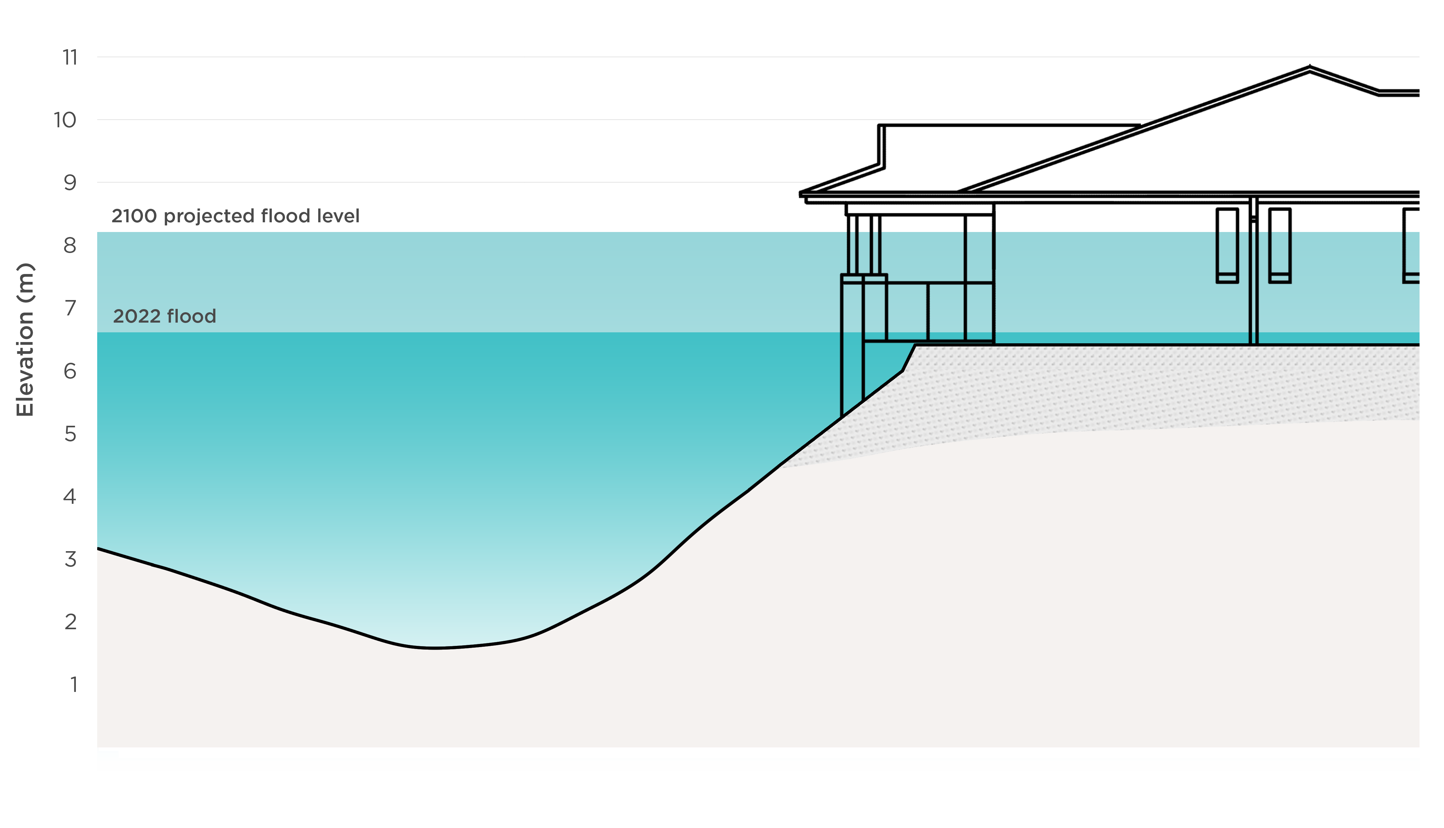
Source: Victorian Ombudsman projection, based on Melbourne Water data. Not to horizontal scale. Site plans suggest 13 homes are built at the depicted levels, though outcomes will vary across Rivervue due to differing locations, designs and floor levels.
Figure 31: How projected 2100 flooding could affect some Kensington Banks homes
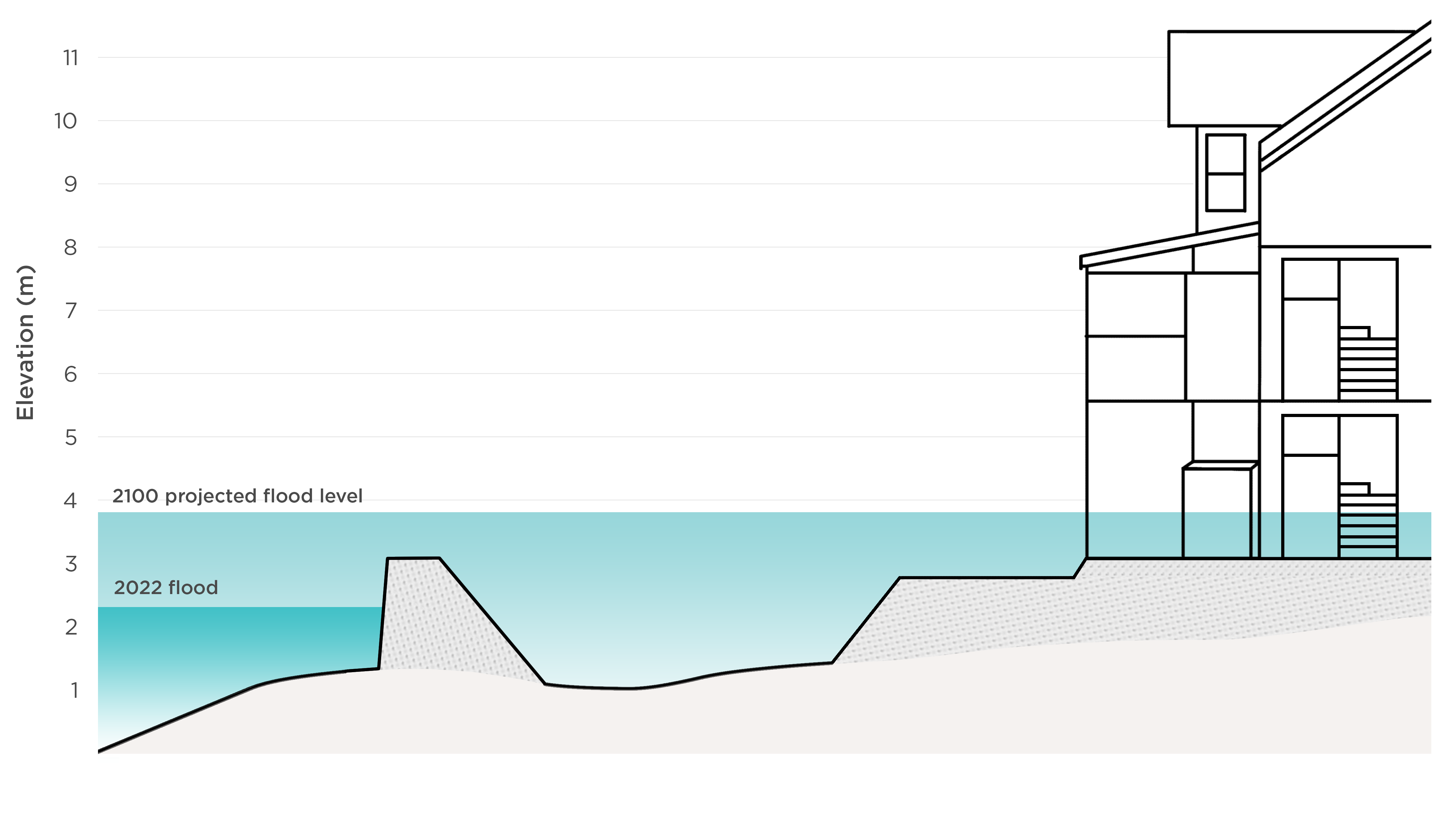
Source: Victorian Ombudsman projection, based on Melbourne Water data. Not to horizontal scale. Note this is one example, and outcomes will vary across Kensington Banks due to differing locations, designs and floor levels.
Melbourne Water now models for future conditions based on climate change projections. Importantly, it is proposing to add these flood maps to relevant planning schemes, ensuring homes built today are designed to meet conditions projected for 2100.
We consider this approach should become standard. Yet it is currently unclear whether the Minister for Planning will approve Melbourne Water’s proposed planning scheme amendments.
Adopting a long-term planning horizon will be unpopular with some. It is already difficult and time consuming to update planning schemes to reflect current conditions, let alone estimates of future risk.
Embedding a 2100 flood planning horizon into the Victoria Planning Provisions, as is already done for coastal erosion, would assist local authorities to take necessary preventative action.
It is also important that flood models continue to be updated as our understanding of climate change improves. Melbourne Water’s 2024 flood model, although cutting edge when prepared, came before major updates to climate change guidance in Australian Rainfall and Runoff. The model’s projections for 2100 are now possibly too conservative.
Victoria’s Climate Science Report 2024 outlines five emissions pathways with differing forecasts of global temperature increases. To ensure consistency, the Victorian Government should clarify which emissions pathway should be adopted for floodplain management purposes.
| About the five emissions pathways |
| Scientists have developed five ‘what if’ scenarios to help understand global climate impacts from greenhouse gas emissions. The most optimistic pathway assumes a ‘gradual move towards sustainability and environmental respect’ around the world, such as switching to renewable energy and adopting new technology to remove carbon dioxide. The least optimistic assumes ‘rapid growth at the expense of the environment’, and increased fossil fuel use. The forecast global temperature change by 2100 differs between the scenarios, from a 1.0 to 1.8°C increase at best, to a 3.3 to 5.7°C increase under the current highest emissions scenario. |
What other inquiries have recommended
Maribyrnong River Flood Event Independent Review (August 2023)
Recommendation 4: Melbourne Water should take account of the best estimates of the impact of climate change when setting flood levels for planning and development and the application of the Land Subject to Inundation Overlay.
- Accepted (Melbourne Water)
Legislative Council Environment and Planning Committee Inquiry into the 2022 Flood Event in Victoria (July 2024)
Recommendation 18: That the Victorian Government introduce amendments to the Planning and Environment Act 1987 (Vic) and Victoria Planning Provisions so that planning and other authorities must address climate change at all levels of the planning process.
- Supported in full (Victorian Government)
Recommendation 19: That the Victorian Government work with floodplain management authorities and climate scientists to understand how modelling can be used to better predict the impact of climate change on flooding and update its flood management policies in line with this understanding.
- Supported in full (Victorian Government)
Helping people living in floodplains
Major floods are projected to get larger in Victoria as climate change ramps up. This is starting to show in flood modelling and will soon be reflected in many planning schemes.
This means experiences at Rivervue and Kensington Banks are not unique. Though our scope was limited to these two developments, other communities along the Maribyrnong were equally surprised by the 2100 modelling. And in the coming years, many other Victorian households will suddenly learn their homes are at increased risk of flooding.
The Victorian Government needs to consider how best to inform and support people when this news is received. What has happened at Rivervue and Kensington Banks shows a ‘buyer beware’ approach is not always fair or practical.
Those facing increased flood risk need clear and authoritative information – about property impacts, insurance costs, and potential mitigation. Rivervue and Kensington Banks provide an opportunity to pilot a new, community-centred approach to communicating flood risk.
Flood mitigation takes many forms – ranging from relatively minor home modifications to very expensive public infrastructure. When done well, it can deliver major long-term cost savings to the community.
Melbourne Water is investigating mitigation options that may yet provide a measure of relief to people at Rivervue and Kensington Banks. But these options are uncertain, unfunded and are still many years away from implementation.
In the meantime, and until structural flood mitigation is in place, the Victorian Government needs to recognise its role in creating the situation facing residents at both developments.
Flooding at Rivervue is primarily attributable to serious mistakes by Melbourne Water during development. In the short term, at least, this has left vulnerable people living in an area which poses a risk to them.
The situation at Kensington Banks is more nuanced, without clear planning errors. But government was heavily involved in designing and implementing flood protection works, and arranging for planning approvals. Residents will likely require further information and support as they adjust to living in a designated floodplain – as will other communities who find themselves in the same situation in future. This is an opportunity to trial a new approach, informed by what has worked well in other jurisdictions.
More broadly, we also endorse the recommendation of the Inquiry into the 2022 Flood Event in Victoria for a funded resilient homes program to raise and retrofit properties at risk, prioritising those impacted by recent flooding. The Victorian Government has rejected this recommendation, but we think it should reconsider.
What other inquiries have recommended
Legislative Council Environment and Planning Committee Inquiry into the 2022 Flood Event in Victoria (July 2024)
Recommendation 22: That the Victorian Government support residents within 1% AEP floodplains, including with funded programs, to manage the risk facing their existing properties and make their properties more flood resilient.
- Supported in principle (Victorian Government)
Recommendation 23: That the Victorian Government fund a resilient homes program to raise or retrofit residential properties at risk of flood inundation, and which priorities homeowners affected by the 2022 flood event.
- Not supported (Victorian Government)
Conclusions
The Legislative Council required us to investigate flood planning decisions for two residential developments along the Maribyrnong River: Rivervue and Kensington Banks.
Both have much in common. Each involved flood protection works promising to protect homes; and yet each is now considered flood prone.
Together, they tell a broader story about how flood risk is assessed and managed in Victoria and highlight serious gaps in existing systems.
Rivervue
Flooding of Rivervue in October 2022 was a disaster, causing displacement, trauma and serious property damage.
This took residents by complete surprise. To their knowledge, homes were designed to withstand flooding, and official flood guides included no warning of potential danger.
We found the effectiveness of flood protection works designed to shield Rivervue was compromised by unreliable data from Melbourne Water.
The data came from a flood model Melbourne Water commissioned in 2003 specifically to assess the Rivervue development. This produced flood levels that were too low, resulting in Rivervue being built too low.
The flood model was rushed, flawed and not fit for purpose. Red flags that should have been obvious to Melbourne Water were overlooked.
This was most likely due to a sense of urgency surrounding the pending Rivervue development, and because attention was focussed elsewhere on the contentious Flemington Racecourse wall proposal.
Even so, homes likely would not have flooded in October 2022 if not for a second, compounding error: development plans used the wrong set of flood levels, and homes were built without a full safety buffer.
This was most likely caused by confusion between two different types of figures supplied by Melbourne Water. The technical mistake should have been caught by Melbourne Water but was not. Moonee Valley City Council then signed off on the faulty plans.
The combined effect of these two errors was that Rivervue’s foundation was set too low from the start, and homes were then built even lower than intended.
This meant they were not equipped to deal with a flood of the size experienced in October 2022, let alone larger floods expected in future.
Understandably, residents were concerned about the removal of a significant flood planning control in late 2016. But we found this had no material impact on Rivervue’s design, or its eventual flooding.
With the benefit of hindsight, removal of the planning control was incorrect. However it was hard to fault the planning bodies involved – all followed Melbourne Water’s advice that the area was no longer flood prone. This advice was wrong because, like the flood protection works, it was based on faulty flood modelling.
We found no evidence of improper influence in the decision, nor in Rivervue’s broader development. Like residents, Rivervue’s owner was let down by poor decision making at Melbourne Water.
Removal of the planning control was not without consequence. It meant Rivervue was left out of official flood guides and other materials based on the planning scheme, promoting a false sense of security.
Residents are now left to live in homes where flooding is considered to pose a particular risk to older residents or those needing extra support, with no substantive recourse yet offered.
Kensington Banks
Homes at Kensington Banks did not flood in October 2022, but new flood modelling indicates many are now at risk.
Residents are understandably concerned, questioning why government-managed flood protection works at the award-winning development no longer appear to be working.
We identified no red flags in the original design of Kensington Banks. Flood protection works were based on good quality flood modelling completed by Melbourne Water in 1986, and should have been sufficient to deal with estimated flood levels of the time.
But catchment conditions have since changed. Development in surrounding areas has increased runoff, and climate change is beginning to impact rainfall patterns. While recognised as potential drivers of flood risk, neither was meaningfully factored into planning at Kensington Banks, where flood protection works were, in effect, designed to handle static conditions.
Infrequent and flawed flood modelling by Melbourne Water let residents down. The sole previous update to the lower Maribyrnong catchment flood model was more than 20 years earlier, in 2003.
Although better designed than the model used at Rivervue, it was not calibrated to past flood events, reducing its reliability. This represented a missed opportunity to critically reassess flood risk at Kensington Banks.
With these issues in mind, it is not surprising that Melbourne Water’s 2024 flood model – prepared thirty years after Kensington Banks construction began – has produced new flood levels for the area.
Different flood models produce different results, and the new flood model is a marked improvement from previous efforts. Rigorously designed in line with modern standards, Kensington Banks residents can generally have confidence in its results (pending resolution of dual concerns we have identified about the levee).
But this will be cold comfort to those with homes in the newly expanded floodplain. Like at Rivervue, Kensington Banks residents face an uncertain future, waiting to see if promised flood mitigation works deliver.
Broader themes
Experiences at Rivervue and Kensington Banks show the planning framework is currently letting Victorians down.
Good flood planning requires a responsive planning system capable of adjusting to new information. This is not happening, with several changes needed.
First, flood modelling must be reliable and up to date to ensure decisions are made on the best available information. Poor or infrequent modelling undermines everything.
Second, traditional flood modelling approaches need reconsidering. We can no longer assume past flooding predicts current and future flood risk. Catchment conditions are changing, and urbanisation and climate change are making things worse. Flood maps must reflect how risk is expected to change over time.
Third, planning schemes must be updated to reflect new flood modelling as soon as is practical. This has not been happening. Changes recently announced by the Victorian Government, under which the Minister for Planning will take control of flood-related planning scheme amendments, finally look set to tackle the issue.
Fourth, new development should be built to withstand future conditions, not just flood risk of the day. This means setting a ‘planning horizon’ which takes into account climate change.
Fifth, people need access to better information. Whether intended or otherwise, planning schemes are currently treated as a key indicator of flood risk. Delays adding new flood maps mean people are not kept properly informed.
Other sources can also be difficult to access and sometimes decades out of date. Promoting a ‘shared responsibility’ to address flood risk requires information to be centralised and accessible. Official sources can also better communicate how risk is constantly being reassessed.
Finally, climate change means the government must prepare for more homes to be reclassified as flood prone. Experiences at Rivervue and Kensington Banks highlight our responsibility to assist those impacted, particularly when poor government decision making and short-term thinking are to blame.
Melbourne Water response
Melbourne Water said it was committed to supporting our investigation and would work closely with the Victorian Government to address our recommendations.
Melbourne Water emphasised that well before the October 2022 flood, it secured extra funding for its Greater Melbourne Flood Modelling Program. This ‘huge technical undertaking’ aims to complete or update about 250 flood models across 38 local government areas by 2026. As with the Maribyrnong catchment, new flood maps will project flood risk to the year 2100, based on the best available information about climate change impacts.
Melbourne Water told us that new technologies and funding had only recently made it possible to continuously review and update its flood models, and the expectation that models should be revised every 5 to 10 years was a relatively new development. It noted that, though aged, its 1986 and 2003 Maribyrnong catchment flood models proved ‘largely accurate’, except at the Rivervue and Kensington Banks sites.
Melbourne Water observed a range of decision-makers and expert planners were involved in designing and assessing the Rivervue development. It believed some relevant records were potentially misplaced, limiting understanding of why it approved changes to floor levels. It noted of almost 200 properties removed from the Land Subject to Inundation Overlay in 2016, to its knowledge, only those at Rivervue flooded in October 2022.
Melbourne Water emphasised the steps it took to inform local communities about the 2024 Maribyrnong catchment flood model before and after its release. This included face-to-face and online information sessions, door knocks, and distribution of information bulletins to more than 8,000 affected properties. It nevertheless acknowledged timing of the model’s release meant it was unable to engage as fully with local communities as it would have liked, falling short of public expectations. It said it had learnt from this, and feedback would help shape the future rollout of the broader flood modelling program.
Melbourne Water said it would continue to listen to the community to understand how people want to receive information about flood risk.
Recommendations
The need for change
Experiences at Rivervue and Kensington Banks highlight the need to improve how our planning system handles flood risk, and how the community is informed and supported.
Many stakeholders contributed thoughts for improvement to our investigation. Our recommendations are based on this input, as well as modern floodplain management principles.
We consulted with a range of authorities about our recommendations, and have included their response, where available.
Planning based on the best information
Until recently, responsibility for flood modelling currently sat with Melbourne Water and local councils, supported by catchment management authorities. Different regions would take different approaches to modelling, with varying results.
Flood maps then needed to be inserted into the planning scheme. Councils would initiate planning scheme amendments and the Minister for Planning approve them. For a variety of reasons, this often took far too long, and in some cases didn’t happen at all.
This approach clearly did not work. Splitting key responsibilities among dozens of local councils was inefficient and promoted inconsistent outcomes. In some cases, planning decisions were being made based on flood information already known to be out of date and unreliable.
Changes announced in October 2025 look set to improve things. In future, flood modelling will be led statewide by catchment management authorities, rather than local councils. We think this is a change for the better, though centralising responsibility in a single authority such as the Department of Energy, Environment and Climate Action remains our preferred solution, and should be considered if outcomes do not improve.
Under the recently announced changes, the Minister for Planning will also take responsibility for leading flood-related planning scheme amendments, similar to the approach taken for bushfire controls. While the results of these reforms will take time to show, the aim should be to ensure flood maps are promptly inserted into planning schemes as they become available.
Community consultation remains vital, but should be concentrated at the flood modelling stage where local knowledge is critical. Those objecting to new flood maps should be empowered to request a review, but not before the planning scheme is updated.
It is recommended that:
| Recommendation 1 The Victorian Government designate a central point of responsibility for modelling riverine flood risk. Department of Transport and Planning response: Accepted in principle Department of Energy, Environment and Climate Action response: Supported in principle [We note the Victorian Government announced reforms in October 2025 assigning responsibility for modelling riverine flood risk to catchment management authorities.] |
Recommendation 2 The Department of Transport and Planning and Minister for Planning assume responsibility for inserting new and updated riverine flood maps into planning schemes as they become available, adopting a similar approach to that taken when updating Bushfire Management Overlays. Department of Transport and Planning response: Accepted in principle [We note the Victorian Government announced reforms in October 2025 to this effect.] |
Planning for a changed climate
Climate change threatens to upend traditional planning approaches. Catchments are changing, and homes built today must be designed to withstand tomorrow’s conditions.
Flood modelling needs to take climate change projections into account. Technical guidance for doing so already exists, but results vary depending on assumptions made about future carbon emissions.
To ensure consistency, the Department of Energy, Environment and Climate Action should identify the most appropriate emissions pathways for flood modelling and review these regularly.
Planning authorities assessing proposed development in the floodplain should also be required to consider climate change projections, where available.
This means planning schemes should adopt a ‘planning horizon’ factoring in climate change, similar to the approach already taken for coastal flooding and erosion.
It is recommended that:
Recommendation 3The Department of Energy, Environment and Climate Action: (a) recommend the most appropriate emissions pathway(s) for flood modelling; and (b) specify the interval at which this decision will be reviewed. Department of Energy, Environment and Climate Action response: Accepted in principle |
Recommendation 4The Department of Transport and Planning and Minister for Planning amend the Victoria Planning Provisions to: (a) provide that, going forward, and where practical, planning schemes should identify land subject to flooding based on climate change projections (eg adopting a 2100 planning horizon); and (b) require planning authorities to consider this information, where available, when assessing the potential risk to life, health and safety associated with a proposed development. Department of Transport and Planning response: Accepted in principle |
Living with flood risk
Not all flooding is the same. Flood hazard depends on a range of factors, including the speed and depth of flood waters. It is possible to safely build in low hazard areas.
Where possible, planning schemes should help identify flood hazard levels, as well as development controls tailored to them. Proposed sensitive uses – such as retirement villages – should always be directed away from higher hazard areas.
It is recommended that:
Recommendation 5The Department of Transport and Planning and Minister for Planning support Melbourne Water’s proposed amendments to the Melbourne, Maribyrnong, Moonee Valley, and Brimbank planning schemes introducing updated planning controls, overlays, and zones incorporating flood hazard categories. Department of Transport and Planning response: Accepted in principle |
Recommendation 6 The Department of Transport and Planning and the Minister for Planning add retirement villages to the list of ‘emergency and community facilities’ in Clause 13.03-1S of the Victoria Planning Provisions that are required to be located outside the 1% AEP floodplain, and consider whether any further additions should be made. Department of Transport and Planning response: Accepted in principle |
Supporting informed decisions
Governments and communities share the responsibility to manage flood risk. But this approach only works if the public has access to reliable information.
Currently flood information is found across multiple sources. The level and quality of information also depends on the catchment.
Victoria needs a modern, accessible flood information portal that reflects the most up to date modelling. This should allow searches at the property level, showing the extent and depth of estimated flooding, when the catchment was last modelled, and when the model is next expected to be reviewed. Climate change projections should also be included, where available.
Information provided to people buying and renting property should also clearly warn of flood risk and emphasise that this can change over time.
It is recommended that:
Recommendation 7 The Department of Energy, Environment and Climate Action, in collaboration with Melbourne Water, local councils and catchment management authorities, develop and make available to the public a statewide flood information portal. This should allow searches at the property level, showing, where practical: (a) the extent and depth of estimated flooding (b) when the catchment was last modelled; and (c) when the model is next expected to be reviewed. Climate change projections should also be included, where available. Department of Energy, Environment and Climate Action response: Accepted in principle |
Recommendation 8 The Department of Transport and Planning amend the information available in planning property reports to: (a) include general information about potential flood risk; and (b) when established, encourage users to consult the statewide flood information portal for further information. Department of Transport and Planning response: Accepted |
Recommendation 9 The Victorian Government amend regulation 16 of the Residential Tenancies Regulations 2021 to require rental providers to disclose to renters before entering into a residential rental agreement whether the rented premises are subject to risk of flooding. Department of Government Services response: Accepted in principle |
Supporting people impacted by flood risk
As part of the referral, the Legislative Council instructed us to consider ‘compensation, support and proposed measures and solutions for residents in the affected areas’.
Rivervue
Flooding of Rivervue homes in October 2022 is primarily attributable to errors made by Melbourne Water during development. These were recognisable and avoidable.
Some residents remain significantly out of pocket due to temporary accommodation, storage, furniture and appliance replacement, and other costs.
The Victorian Government has a responsibility to compensate flood-affected residents for these expenses, where not already covered by the retirement village operator or insurance.
Many people at Rivervue also told us they feel trapped, unable to leave devalued homes for fear of incurring significant capital losses.
We consider the Victorian Government also has a responsibility to assist those who, for no fault of their own, now find themselves living out their retirement in a ‘medium’ hazard flood area that is considered to pose particular risks for ‘older residents, and those needing extra support’.
The support program should assist flood-affected residents who wish to leave Rivervue before promised structural flood mitigation works are in place.
Residents who sell their homes at a capital loss should be compensated, provided reasonable efforts have been made to sell at or above the original purchase price. Compensation would be fixed at the difference between the purchase and sale price (less any reduction in fees), and would not extend to exit fees ordinarily payable under the Residence and Management contract.
Many residents moved in with an expectation property values would increase, and they would ultimately sell out for a higher price. However, we do not recommend the scheme cover any ‘lost’ capital gains for those who sell, or those who stay.
Nor do we recommend flood resilience grants for Rivervue residents to make home improvements, because they lease rather than own their homes.
The Victorian Government should, however, be prepared to support reasonable structural flood defence options for Rivervue, where identified and recommended by Melbourne Water’s forthcoming flood mitigation study.
In the longer term, if flooding at Rivervue cannot be appropriately mitigated and the area remains at a hazard level posing particular risks for older people, land acquisition from the village operator should also be considered.
It is recommended that:
Recommendation 10 The Victorian Government establish a support fund for flood-affected Rivervue residents within 12 months. The support fund should offer compensation for: (a) direct economic loss reasonably attributable to the October 2022 flood (b) realised capital loss reasonably incurred by residents who choose to sell their homes during a fixed eligibility period, less any reduction in exit fees arising from the loss. Department of Transport and Planning response: Not supported. [The Department, after consulting on our draft report with the Department of Premier and Cabinet, the Department of Treasury and Finance and the Department of Energy, Environment and Climate Action, said setting up a support fund would require a Cabinet decision. It said the Victorian Government would 'carefully consider' the findings and recommendations in our final report.] |
Kensington Banks
Unlike Rivervue, flooding at Kensington Banks is not attributable to clear errors during planning of the estate. There are a range of factors contributing to reassessed flood risk, including catchment changes and improved flood modelling.
Problems with the flood protection levee around the perimeter may also be contributing, and require further investigation.
The situation at Kensington Banks is likely to be repeated across large parts of Melbourne, as climate change projections continue to be incorporated into flood models and planning controls.
The Victorian Government has a responsibility to inform and educate people about reassessed flood risk as this happens. Communication must be sensitive to the needs of the community.
We recommend the Victorian Government collaborate with Melbourne Water and the City of Melbourne to prepare a pilot information package for affected Kensington Banks residents which, if successful, could then be rolled out to other communities facing similar issues.
This should include clear information about reassessed flood risk, options for improving flood resilience, insurance options, the progress of related planning scheme amendments, and a flood risk management plan for the estate.
It is recommended that:
Recommendation 11Melbourne Water, in collaboration with the City of Melbourne, investigate the height of the Kensington Banks flood protection levee, and: (a) consider, as part of the Maribyrnong River Catchment Flood Mitigation Study, whether flood risk can be mitigated by repairs or improvements to the levee (b) consider whether relevant inputs to the 2024 flood model should be updated. Melbourne Water response: Accepted City of Melbourne response: Supported |
Recommendation 12The Victorian Government, in collaboration with Melbourne Water and the City of Melbourne, prepare and deliver a pilot information package for Kensington Banks residents impacted by reassessed flood risk. The information package should be launched within six months. Department of Transport and Planning response: Accepted in principle Department of Energy, Environment and Climate Action response: Supported in principle City of Melbourne response: Supported |
The Victorian Government was central to the development of Kensington Banks, including the flood protection works which now appear to be failing.
The project was hailed at the time for finding innovative solutions for flood risk to meet a pressing need for housing. A similar mindset is now required to meet the fresh challenges facing the estate.
Structural mitigation may yet bring flood risk at Kensington Banks back within acceptable levels. If a suitable flood mitigation option isn’t identified and supported, we recommend the Victorian Government deliver further support to residents unable to afford flood resilience home improvements.
This could be modelled on interstate offerings and follow a similar approach to the Victorian Energy Upgrades program.
While confined to Kensington Banks, lessons from such a pilot program would help guide how other Victorian households might adapt to meet similar challenges in coming decades.
In the event that Melbourne Water’s Maribyrnong River Catchment Flood Mitigation Study does not identify a supported flood mitigation option for Kensington Banks, it is recommended that:
Recommendation 13The Victorian Government establish a resilience program for residents. The resilience program should be means-tested, and offer subsidies for property-level flood resilience assessments and flood resilience upgrades. Department of Transport and Planning response: Not supported. [The Department noted a similar recommendation was made by the Legislative Council Environment and Planning Committee's Inquiry into the 2022 Flood Event in Victoria. That recommendation was not supported by the Victorian Government.] |
Appendix 1: The investigation
Authority to investigate
The investigation was conducted under section 16(2) of the Ombudsman Act, following a referral from the Legislative Council under section 16(1).
Section 16(2) requires us to ‘forthwith investigate’ a matter referred by Parliament under section 16(1) and ‘report thereon’.
How we investigated
We met with relevant stakeholders and opened a public submissions process to hear from residents at Rivervue and Kensington Banks.
We also undertook historical research, gathered relevant records from a range of public bodies, and sought technical advice where appropriate.
We acknowledge cooperation and assistance provided by Melbourne Water, Moonee Valley City Council, the City of Melbourne, the Department of Transport and Planning, the Department of Energy, Environment and Climate Action, the Department of Government Services, the Department of Premier and Cabinet, the Minister for Planning, Development Victoria, Valuer-General Victoria, Public Record Office Victoria, the Victorian Civil and Administrative Tribunal, the Supreme Court of Victoria, Rivervue’s engineer, and Rivervue’s current owner.
We also thank everyone who contributed their experiences and thoughts for improvement through the submissions process.
The investigation involved:
- visiting the Rivervue and Kensington Banks developments
- reviewing public submissions received and seeking further information where necessary
- considering the findings and evidence considered by a range of other inquiries, including:
- Melbourne Water’s Maribyrnong River Flood Event Independent Review, reports dated August 2023 and April 2024
- the Legislative Council Environment and Planning Committee’s Inquiry into the 2022 Flood Event in Victoria, report dated July 2024
- the Australian Parliament House of Representatives Standing Committee on Economics’ Inquiry into Insurers’ Responses to 2022 Major Floods Claims, report dated October 2024
- the Victorian Government’s Review of the 2010-11 Flood Warnings & Response, report dated December 2011
- the Legislative Council Environment and Planning Committee’s Inquiry into Climate Resilience, report dated August 2025
- considering relevant legislation, regulations and subordinate legislation, including:
- Planning and Environment Act 1987
- Water Act 1989
- Catchment and Land Protection Act 1994
- Building Regulations 2018
- reviewing relevant strategies, policies and technical standards relating to floodplain management, including:
- Australian Rainfall and Runoff – A Guide to Flood Estimation, published by Engineers Australia (1987 edition) and the Australian Government (2019 and 2024 editions)
- the Victorian Floodplain Management Strategy and Victorian Flood Data and Mapping Guidelines, both published by the former Department of Environment, Land, Water and Planning in 2016
- AM STA 6200 Flood Mapping Projects Specification adopted by Melbourne Water and last updated in August 202
- gathering and reviewing records relating to Rivervue and Kensington Banks, in some cases under summons, including:
- historical materials held by Public Record Office Victoria
- flood modelling, floodplain management, and development assessment records from Melbourne Water
- planning records held by Moonee Valley City Council, the City of Melbourne, and the Department of Transport and Planning
- Kensington Banks project records held by Development Victoria
- court and tribunal records from the Victorian Civil and Administrative Tribunal and the Supreme Court of Victoria
- interviewing witnesses responsible for decisions relating to Rivervue and Kensington Banks, including:
- current and former Melbourne Water staff
- a representative of Rivervue’s current owner
- the Chair of the planning panel responsible for considering removal of the planning control at Rivervue
- the former Kensington Banks Project Manager
- seeking and considering advice from a technical specialist, Adjunct Professor James Ball
- consulting with relevant stakeholders about proposed recommendations.
Appendix 2: Glossary
| Term | Definition |
| 1% AEP flood | 1% Annual Exceedance Probability flood. Used as a benchmark for planning. There is a 1 in 100 chance a flood this size (or larger) could occur in any given year. |
| 1986 model | Flood model prepared in 1986 to estimate flood risk in the lower part of the Maribyrnong catchment, covering the future site of Kensington Banks but not Rivervue. |
| 2003 modelling | 2003 update of the 1986 model covering a larger part of the Maribyrnong catchment. Made up of three parts:
|
| 2024 model | Flood model of the Maribyrnong catchment prepared in 2024 covering Kensington Banks and Rivervue. |
| AHD | Australian Height Datum. The official reference system for height across Australia. 0.0 metres AHD is about average sea level. |
| Amendment C151 | Amendment to the Moonee Valley Planning Scheme to update flood-related planning controls at Rivervue and elsewhere. |
| Australian Rainfall and Runoff – A Guide to Flood Estimation | Leading technical guide for flood modelling. |
| Calibration | Use of historic flood data to check and adjust a flood model. |
| Catchment | Area of land where rainwater collects and feeds into a particular waterway. |
| City of Melbourne | Local council for Kensington Banks. |
| Design flood | Hypothetical flood used to define flood risk areas for planning and floodplain management purposes. In Victoria, this is the 1% AEP flood. |
| Finished floor levels | Surface height of the lowest floor of a building. |
| Flood | Temporary overflow of water onto land that is normally dry. |
| Flood defence | Structure or system built to reduce flood risk. Also referred to as ‘flood protection’ or ‘flood mitigation’. |
| Flood hazard | Potential harm or loss caused by flooding. |
| Flood level | Estimated height above sea level a flood might reach. Also referred to in this report as the ‘flood line’. |
| Flood map | Map showing how areas are likely to be affected by flood. |
| Flood mitigation | Measures taken to reduce flood risks. Also referred to as ‘flood defence’ or ‘flood protection’. |
| Flood model | Tool to estimate where flooding could go, and how deep it could get. |
| Flood risk | How likely it is a flood will occur, and the consequences if it does. |
| Flood storage | Area of floodplain that temporarily holds floodwater. |
| Floodplain | Land next to waterways that is prone to flooding. |
| Floodplain management | Actions taken to meet a range of social, economic, and environmental objectives on floodplains. |
| Floodplain management authority | Body consulted about development on land affected by a flood-related planning control. |
| FMA | Floodway Management Area. Former planning control applied over land at risk of flooding. |
| Freeboard | Safety buffer to raise floor levels above the estimated flood height. |
| Inquiry into the 2022 Flood Event in Victoria | Inquiry by the Legislative Council Environment and Planning Committee into the October 2022 flood. |
| Insurance Council of Australia | Representative body of the general insurance industry in Australia. |
| Kensington Banks | Residential estate beside the Maribyrnong River in Kensington. |
| Levee | Raised structure built to reduce flood risk. |
| LSIO | Land Subject to Inundation Overlay. Planning control applied over land at risk of flooding from waterways and coastal areas. |
| Lynch’s Bridge | Urban renewal project that included the Kensington Banks development. |
| Major Projects Unit | Victorian Government Major Projects Unit. Former state government body that planned and oversaw the Kensington Banks development. |
| Maribyrnong River Flood Event Independent Review | Review commissioned by Melbourne Water into the October 2022 flooding of the Maribyrnong River. |
| Melbourne Water | Floodplain management authority for Rivervue and Kensington Banks. Previously known as the Melbourne and Metropolitan Board of Works. |
| Minister for Planning | Victorian Government Minister responsible for approving planning scheme amendments and certain large-scale developments. |
| Moonee Valley City Council | The local council for Rivervue. |
| Municipal Association of Victoria | The representative and advocacy body for Victoria’s local councils. |
| October 2022 flood | Flooding experienced across Victoria in October 2022, including along the Maribyrnong River and at Rivervue. |
| Office of Major Projects | Another name for the Major Projects Unit (see above). |
| Overland flow and drainage modelling | Model of stormwater flooding. |
| Overlay | Identifies land where specific controls apply (eg due to natural hazards such as flooding or bushfires). |
| Planning control | Planning scheme provision that regulates how land can be used or developed. |
| Planning panel | Independent body appointed by the Minister for Planning to hear submissions about and provide advice on planning scheme amendments. |
| Planning permit | Legal document that approves a use or development needing permission under the planning scheme. |
| Planning scheme | Statutory document specifying rules about land use and development in an area. |
| Riverine flooding | Flooding caused by overflow from a river, creek, lake, dam, or other water body. |
| Rivervue | Retirement village beside the Maribyrnong River in Avondale Heights. |
| Run-off | Rainwater that flows over surfaces or into waterways instead of absorbing into the ground. |
| Soil compaction | Lowering of ground elevation due to soil particles compressing together. |
| Special Building Overlay | Planning control applied to areas prone to flooding from stormwater or if drains fail. |
| Stormwater flooding | Overflow of water from urban drains onto land that is normally dry. |
| Total energy line | Measure of water levels. Shows the potential increase in flooding when water is obstructed. Always higher than water surface elevation. |
| VCAT | Victorian Civil and Administrative Tribunal |
| VicPlan | Online tool provided by the state government for viewing planning information about properties. |
| Victoria Planning Provisions | Set of standard provisions from which a planning scheme must be assembled. |
| Victorian Flood Data and Mapping Guidelines | Non-technical guidance for flood models published by the former Department of Environment, Land, Water and Planning in 2016. |
| Victorian Floodplain Management Strategy | Policy of the former Department of Environment, Land, Water and Planning in 2016 to direct floodplain management across Victoria. |
| Water surface elevation | Measure of water levels. Usually used to set floor levels. |
| Waterway | Area where water flows, eg river, creek or estuary. |
| Zone | Sets out the purpose of land and how it can be used (eg residential development or agriculture). |
Appendix 3: Rivervue Residents’ Committee response
